|
search place name
|
||
Pelārt (Eşfahān, Iran)Pelārt is a town in the Eşfahān region of Iran. An overview map of the region around Pelārt is displayed below.
regional and 3d topo map of Pelārt, Iran ::

Nearby towns ::
Khūnsārak (1.0km north) //
Zūdān (1.6km south) //
Now Darāmad (1.5km south east) //
Pīr Bakrān (1.7km west) //
Pāvā (1.7km north west) //
Tamandegān (2.1km east) //
Sangāncheh (2.4km north west) //
Mehrejān (2.2km east) //
Pelārtegān (2.6km south) //
Dar Afshān (2.5km south east) //
Semsān (2.4km south east) //
Kelīsān (2.7km south east) //
Khorūshād (2.7km south west) //
Alī Shāhedān (3.1km north) //
Şādeqābād (2.7km east) //
Mīr Gūn (2.7km north east) //
‘Alīābād (3.1km north east) //
Karafshān (3.0km south west) //
Raḩīmābād (3.5km south) //
Fakhrābād (3.8km south) //
Dārjān (3.6km south west) //
Jūjī (3.4km north west) //
Aḩmadābād (4.0km south) //
Chahār Borj (4.0km north) //
Fakhrābād (4.0km south) //
Qal‘eh-e Sorkh (3.7km north east) //
Sīāh Afshār (3.9km north) //
Ḩājjīābād (3.7km north west) //
Raḩīmābād (3.5km east) //
[all distances 'as the bird flies' and approximate] 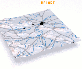 Places with similar names to Pelārt, Iran ::
Disclaimer :: Information on this page comes without warranty of any kind |
||
|
Where is Pelārt? Elevation and coordinates ::
Latitude (lat): 32°27'49"N Longitude (lon): 51°34'38"E
Elevation (approx.): 1633m (map arrows pan, magnifying glasses zoom) |
||
|
Visiting Pelārt? Hotel/Accommodation ::
Book a hotel in Pelārt Travel Guide ::
Buy a travel guide for Iran rental cars ::
car rental offers GPS waypoint ::
download a GPX waypoint (PoI) of Pelārt for your GPS receiver
|
||