|
search place name
|
||
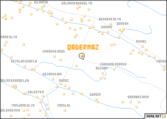
Qāder Maz (Ostān-e Kermānshāh, Iran)Qāder Maz is a town in the Ostān-e Kermānshāh region of Iran. An overview map of the region around Qāder Maz is displayed below.
regional and 3d topo map of Qāder Maz, Iran ::
Qāder Maz airports ::
The nearest airport is KSH - Bakhtaran Shahid Ashrafi Esfahani, located 38.3 km north of Qāder Maz.
Other airports nearby include SDG - Sanandaj (139.1 km north), Nearby towns ::
Kalkūshak (1.9km south west) //
Babrī (4.3km west) //
Būzhān (4.7km south east) //
Bāgh-e Karambeyg (5.3km north) //
Golān (5.2km south east) //
Darāsb (5.7km north) //
Hasht Bākh (5.7km south east) //
Khoshkeh Rūd (5.4km west) //
Dārbadreh (6.1km north east) //
Fīrūzābād Pāchoqā (7.0km north) //
Masgareh (6.9km south west) //
Mehdīābād-e ‘Olyā (7.1km north) //
Cheshmeh Mākān (6.8km north east) //
Gol Darreh (6.9km north east) //
Nūrāz (6.8km south west) //
Cheshmeh Sorkh (6.1km east) //
Poshteh Rīzeh-ye Soflá (7.3km north) //
Qal‘eh-ye Sar Jūb (6.9km south west) //
Cherāghābād (6.7km north east) //
Cheshmeh Shāhrokh (7.7km south) //
Zamānābād (7.6km north) //
Kargān (7.7km north) //
Tāzehābād (7.9km south) //
Hezār Khānī (7.2km south west) //
Govenī (7.6km north east) //
Posht Tang (7.8km south west) //
Nūr-e Soflá (8.6km north) //
Maskareh (8.6km south west) //
Najafābād (8.9km north) //
[all distances 'as the bird flies' and approximate]  Places with similar names to Qāder Maz, Iran ::
// Kaytarmış (TR)
// Katéré Moussa (NE)
Disclaimer :: Information on this page comes without warranty of any kind |
||
|
Where is Qāder Maz? Elevation and coordinates ::
Latitude (lat): 34°0'9"N Longitude (lon): 47°12'17"E
Elevation (approx.): 1712m (map arrows pan, magnifying glasses zoom) |
||
|
Visiting Qāder Maz? Hotel/Accommodation ::
Book a hotel in Qāder Maz Travel Guide ::
Buy a travel guide for Iran rental cars ::
car rental offers GPS waypoint ::
download a GPX waypoint (PoI) of Qāder Maz for your GPS receiver
|
||