|
search place name
|
||
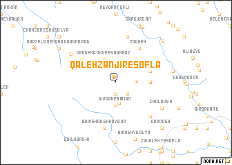
Qal‘eh Zanjīr-e Soflá (Ostān-e Kermānshāh, Iran)Qal‘eh Zanjīr-e Soflá is a town in the Ostān-e Kermānshāh region of Iran. An overview map of the region around Qal‘eh Zanjīr-e Soflá is displayed below.
regional and 3d topo map of Qal‘eh Zanjīr-e Soflá, Iran ::
Qal‘eh Zanjīr-e Soflá airports ::
The nearest airport is KSH - Bakhtaran Shahid Ashrafi Esfahani, located 91.0 km east of Qal‘eh Zanjīr-e Soflá.
Other airports nearby include SDG - Sanandaj (101.9 km north east), Nearby towns ::
Sīāh Khānī (1.9km south) //
Shūyl-e Şādeqkhān (2.4km south east) //
Qal‘eh Zanjīr-e ‘Olyā (2.7km east) //
Dūsh-e Mīān (3.5km south) //
Dīvgah-e Bībīān (3.7km south) //
Gerdekānkūr-e Shahbāz (4.0km north) //
Chālābeh-ye Shāh Moḩammad (4.6km east) //
Dasht-e Mūrt-e Soflá (4.9km east) //
Chālāveh-ye Mavālī-ye Najaf (4.9km east) //
Kadkhodā Moşţafá (5.9km north west) //
Zāgheh (6.3km north east) //
Dashtī Leyl-e Ḩoseynābād (7.6km north) //
Barīshāh-e Khūybār (7.6km south) //
Dengākeh (7.2km south east) //
Chālāveh (7.4km south east) //
Ḩasan Gāyār (7.6km north west) //
Ḩowẕ-e Sheykh-e Zemkān (9.1km north east) //
Dār Rash (9.6km south east) //
[all distances 'as the bird flies' and approximate] 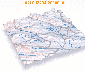 Places with similar names to Qal‘eh Zanjīr-e Soflá, Iran :: Disclaimer :: Information on this page comes without warranty of any kind |
||
|
Where is Qal‘eh Zanjīr-e Soflá? Elevation and coordinates ::
Latitude (lat): 34°36'0"N Longitude (lon): 46°13'0"E
Elevation (approx.): 1493m (map arrows pan, magnifying glasses zoom) |
||
|
Visiting Qal‘eh Zanjīr-e Soflá? Hotel/Accommodation ::
Book a hotel in Qal‘eh Zanjīr-e Soflá Travel Guide ::
Buy a travel guide for Iran rental cars ::
car rental offers GPS waypoint ::
download a GPX waypoint (PoI) of Qal‘eh Zanjīr-e Soflá for your GPS receiver
|
||