|
search place name
|
||
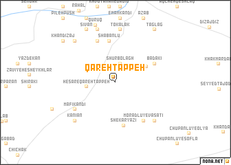
Qareh Tappeh (Ostān-e Āz̄arbāyjān-e Sharqī, Iran)Qareh Tappeh is a town in the Ostān-e Āz̄arbāyjān-e Sharqī region of Iran. An overview map of the region around Qareh Tappeh is displayed below.
regional and 3d topo map of Qareh Tappeh, Iran ::
Qareh Tappeh airports ::
The nearest airport is TBZ - Tabriz Intl, located 117.6 km east of Qareh Tappeh.
Other airports nearby include VAN - Van (139.6 km west), Nearby towns ::
Shūr Bolāgh (3.1km north) //
Ḩeşār-e Qareh Tappeh (3.8km west) //
Mollā Jonūd (4.7km north east) //
Sha‘bānlū (6.8km north) //
Bādakī (5.9km north east) //
Shekar Yāzī (7.1km south) //
Bīlehverdī (7.1km north) //
Morādlū-ye Vasaţī (7.2km south east) //
Māfī Kandī (6.8km south west) //
Tokalāk (8.6km north) //
Morādlū-ye Pā”īn (8.0km south east) //
Hendevān (8.9km north) //
Deljelū (8.9km north) //
Kānīān (8.1km south west) //
Bakhtīārān (8.5km north west) //
Sīvān (9.4km north west) //
Taglag (9.9km north east) //
Khāndīzaj (9.4km north west) //
Ābāţī (9.4km north west) //
[all distances 'as the bird flies' and approximate] 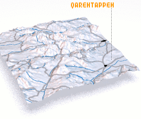 Places with similar names to Qareh Tappeh, Iran ::
Disclaimer :: Information on this page comes without warranty of any kind |
||
|
Where is Qareh Tappeh? Elevation and coordinates ::
Latitude (lat): 38°22'22"N Longitude (lon): 44°55'33"E
Elevation (approx.): 1364m (map arrows pan, magnifying glasses zoom) |
||
|
Visiting Qareh Tappeh? Hotel/Accommodation ::
Book a hotel in Qareh Tappeh Travel Guide ::
Buy a travel guide for Iran rental cars ::
car rental offers GPS waypoint ::
download a GPX waypoint (PoI) of Qareh Tappeh for your GPS receiver
|
||