|
search place name
|
||
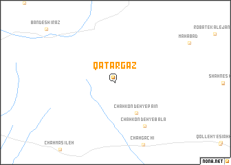
Qaţār Gaz (Khorāsān, Iran)Qaţār Gaz is a town in the Khorāsān region of Iran. An overview map of the region around Qaţār Gaz is displayed below.
regional and 3d topo map of Qaţār Gaz, Iran ::
Qaţār Gaz airports ::
The nearest airport is XBJ - Birjand, located 161.1 km south of Qaţār Gaz.
Nearby towns ::
Chāh Kondeh-ye Pā'īn (5.7km south east) //
Chāh Kondeh-ye Bālā (8.1km south east) //
[all distances 'as the bird flies' and approximate]  Places with similar names to Qaţār Gaz, Iran ::
// Cadorças (PT)
// Quatro Águas (PT)
// Kudrycze (PL)
// Kétérköz (HU)
// Cotîrgaci (RO)
// Cotîrgaci (RO)
// Cotîrgaşi (RO)
// Cattaraugus (US)
// Qaţār Gaz (IR)
// Goudargues (FR)
Disclaimer :: Information on this page comes without warranty of any kind |
||
|
Where is Qaţār Gaz? Elevation and coordinates ::
Latitude (lat): 34°20'14"N Longitude (lon): 59°29'53"E
Elevation (approx.): 857m (map arrows pan, magnifying glasses zoom) |
||
|
Visiting Qaţār Gaz? Hotel/Accommodation ::
Book a hotel in Qaţār Gaz Travel Guide ::
Buy a travel guide for Iran rental cars ::
car rental offers GPS waypoint ::
download a GPX waypoint (PoI) of Qaţār Gaz for your GPS receiver
|
||