|
search place name
|
||
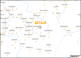
Qatūjā (Iran)Qatūjā is a town in Iran. An overview map of the region around Qatūjā is displayed below.
regional and 3d topo map of Qatūjā, Iran ::
Qatūjā airports ::
The nearest airport is THR - Teheran Mehrabad Intl, located 174.6 km west of Qatūjā.
Nearby towns ::
Sang Līseh (1.9km south) //
Tāj od Dīn (1.5km west) //
Anārūm (3.0km west) //
Nasām Ţalār Sar (3.0km west) //
Khārī Sarā (3.5km south east) //
Qetlīlūm (3.5km south west) //
Darzī Kolā (4.5km north) //
Mīrūzān (4.5km south) //
Band-e Bon (4.8km south east) //
Kaleh (4.8km north west) //
Vazmelā (5.2km north) //
Deh Mīān (4.5km north west) //
Kūh Esţelakh (4.5km west) //
Sang Deh (5.6km north) //
Varī Pey (4.9km west) //
Kolmatā (6.0km south) //
Malek Deh (5.8km south west) //
Mollā Deh (5.8km south west) //
Rajeh (5.6km west) //
Dāvūd Kolā (7.3km north) //
Sowr Kolā (7.4km north) //
Valīk Bon (7.4km north) //
Valīk Chāl (7.6km north) //
Sūteh Kolā (7.6km north) //
Āseh (6.3km west) //
Rajeh (6.3km west) //
Nowraz (7.0km north west) //
Bendelā (7.0km north west) //
Folūrd (7.5km north west) //
[all distances 'as the bird flies' and approximate]  Places with similar names to Qatūjā, Iran ::
Disclaimer :: Information on this page comes without warranty of any kind |
||
|
Where is Qatūjā? Elevation and coordinates ::
Latitude (lat): 36°2'0"N Longitude (lon): 53°12'0"E
Elevation (approx.): 1799m (map arrows pan, magnifying glasses zoom) |
||
|
Visiting Qatūjā? Hotel/Accommodation ::
Book a hotel in Qatūjā Travel Guide ::
Buy a travel guide for Iran rental cars ::
car rental offers GPS waypoint ::
download a GPX waypoint (PoI) of Qatūjā for your GPS receiver
|
||