|
search place name
|
||
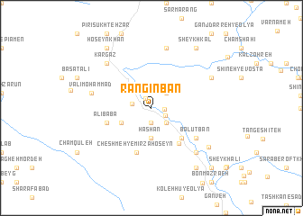
Rangīnbān (Lorestān, Iran)Rangīnbān is a town in the Lorestān region of Iran. An overview map of the region around Rangīnbān is displayed below.
regional and 3d topo map of Rangīnbān, Iran ::
Rangīnbān airports ::
The nearest airport is KSH - Bakhtaran Shahid Ashrafi Esfahani, located 85.8 km north west of Rangīnbān.
Other airports nearby include SDG - Sanandaj (179.3 km north), QMJ - Masjed Soleiman Shahid Asyaee (240.4 km south east), Nearby towns ::
Zarrīn Bon (1.3km north west) //
Ānārsen (1.4km east) //
Mūsombeg (1.9km south) //
Varpol (1.7km south east) //
Darmareh (2.0km west) //
Bahrāmkhān (2.4km south east) //
Pīr ‘Alīdād (2.4km north east) //
Gāvgīr-e Jahrāneh (2.4km south east) //
Hashān (3.7km south) //
Eslāmābād (3.6km south west) //
Bahrām (3.6km south west) //
Cham Dashtī (4.8km south east) //
Cham Palak (5.2km south east) //
‘Alī Bābā (5.0km west) //
Cheshmeh-ye Mīrzā Ḩoseyn (5.8km south) //
Balūţbān (5.9km south east) //
Haft Cheshmeh (7.6km north) //
Valīmoḩammad (6.4km west) //
Pīr Şamadīn (7.2km south east) //
Kargaz (7.2km north west) //
Garmūrt-e Noşratī (7.2km south east) //
Shīrkash (7.2km south east) //
Chahār Āb (7.2km north east) //
Garmūrt-e Ramaẕān (7.6km south east) //
Sheykh Kal (8.7km north east) //
Khāneh Sorkh (8.7km south east) //
Ḩoseynkhān (8.7km north west) //
Zūrāncham (9.6km south east) //
[all distances 'as the bird flies' and approximate]  Places with similar names to Rangīnbān, Iran :: Disclaimer :: Information on this page comes without warranty of any kind |
||
|
Where is Rangīnbān? Elevation and coordinates ::
Latitude (lat): 33°45'0"N Longitude (lon): 47°45'0"E
Elevation (approx.): 1110m (map arrows pan, magnifying glasses zoom) |
||
|
Visiting Rangīnbān? Hotel/Accommodation ::
Book a hotel in Rangīnbān Travel Guide ::
Buy a travel guide for Iran rental cars ::
car rental offers GPS waypoint ::
download a GPX waypoint (PoI) of Rangīnbān for your GPS receiver
|
||