|
search place name
|
||
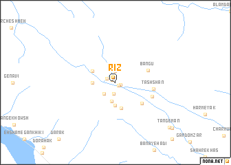
Rīz (Ostān-e Būshehr, Iran)Rīz is a town in the Ostān-e Būshehr region of Iran. An overview map of the region around Rīz is displayed below.
regional and 3d topo map of Rīz, Iran ::
Rīz airports ::
The nearest airport is BUZ - Bushehr, located 156.2 km north west of Rīz.
Other airports nearby include SYZ - Shiraz Shahid Dastghaib Intl (172.8 km north), BAH - Bahrain Intl (243.0 km south west), KIH - Kish Island (253.8 km south east), DHA - Dhahran King Abdulaziz Ab (274.1 km south west), Nearby towns ::
Poshtū (0.6km north west) //
Qal‘eh Kohneh (0.7km south east) //
Eslāmābād (0.8km south east) //
Velāyat (1.4km north west) //
Deh Now (1.9km north) //
Anārestān (1.9km south) //
Nāvestān (2.5km south west) //
Sargū (3.1km south) //
Nārestān (3.7km south) //
Bāgh-e Bīdū (3.3km west) //
Kūh Bardakān (3.8km north west) //
Ḩermī-ye Anārī (4.3km south) //
Kūh Chehr (5.1km south east) //
Bangū (5.0km north east) //
Tashshān (5.6km east) //
Darreh Bān (5.7km south east) //
Tang-e Mān (10.6km south east) //
[all distances 'as the bird flies' and approximate] 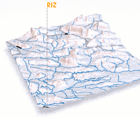 Places with similar names to Rīz, Iran ::
Disclaimer :: Information on this page comes without warranty of any kind |
||
|
Where is Rīz? Elevation and coordinates ::
Latitude (lat): 28°3'0"N Longitude (lon): 52°4'0"E
Elevation (approx.): 336m (map arrows pan, magnifying glasses zoom) |
||
|
Visiting Rīz? Hotel/Accommodation ::
Book a hotel in Rīz Travel Guide ::
Buy a travel guide for Iran rental cars ::
car rental offers GPS waypoint ::
download a GPX waypoint (PoI) of Rīz for your GPS receiver
|
||