|
search place name
|
||
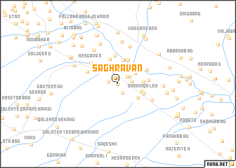
Sāghravān (Khorāsān, Iran)Sāghravān is a town in the Khorāsān region of Iran. An overview map of the region around Sāghravān is displayed below.
regional and 3d topo map of Sāghravān, Iran ::
Sāghravān airports ::
The nearest airport is ASB - Ashkhabad Ashgabat, located 183.1 km north west of Sāghravān.
Nearby towns ::
Moḩammadābād-e Qā'emmaqām (0.0km south) //
Chenār Sūkhteh (1.2km west) //
Kavardeh (1.5km south) //
Tūp Derakht (1.6km north east) //
Devīn (1.9km north east) //
Kalāteh-ye Ḩājjī ‘Alī (1.8km east) //
Solţānābād (2.4km north) //
Jalālī (2.7km north) //
Chāh Mollā (2.6km north east) //
Kalāteh-ye Qorbān (2.8km north east) //
Kharābeh Amīn (3.4km south east) //
Pā'īn Deh (3.2km east) //
Akbarābād (3.9km north) //
Kalāteh-ye Yazdīhā (4.0km north) //
Kalāteh-ye Bāqer (3.3km east) //
Mo'aseseh-e Yek (4.0km north) //
Bāzeh Kalāgh (4.1km north) //
Ashg-e Zarī (4.1km north) //
Fatḩābād-e Yazdīhā (4.1km north) //
Khān Sa‘ādat (3.6km south east) //
Shāhīn Qa‘leh (3.6km south east) //
Shāhīn Qal‘eh (3.6km south east) //
Kalāteh-ye Yazdīhā (4.6km north) //
Chahchaheh (3.9km east) //
Kalāteh-ye Ḩasan (4.3km north east) //
‘Abdolābād (4.3km north west) //
‘Abdolābād (4.3km north west) //
Mesgarān (4.9km north west) //
Gonābād (4.9km north west) //
[all distances 'as the bird flies' and approximate]  Places with similar names to Sāghravān, Iran ::
// Svarven (SE)
Disclaimer :: Information on this page comes without warranty of any kind |
||
|
Where is Sāghravān? Elevation and coordinates ::
Latitude (lat): 36°31'48"N Longitude (lon): 59°19'47"E
Elevation (approx.): 1105m (map arrows pan, magnifying glasses zoom) |
||
|
Visiting Sāghravān? Hotel/Accommodation ::
Book a hotel in Sāghravān Travel Guide ::
Buy a travel guide for Iran rental cars ::
car rental offers GPS waypoint ::
download a GPX waypoint (PoI) of Sāghravān for your GPS receiver
|
||