|
search place name
|
||
Sarand (Ostān-e Āz̄arbāyjān-e Sharqī, Iran)Sarand is a town in the Ostān-e Āz̄arbāyjān-e Sharqī region of Iran. An overview map of the region around Sarand is displayed below.
regional and 3d topo map of Sarand, Iran ::

Sarand airports ::
The nearest airport is TBZ - Tabriz Intl, located 38.6 km south west of Sarand.
Nearby towns ::
Daghdaghān (3.0km north) //
Shālī (3.3km south west) //
Bashīr (3.6km south east) //
Beshīr (3.6km south east) //
Chanzanaq (4.3km south west) //
Tāzeh Kand-e Sarand (5.2km north) //
Shahrak-e Aḩmadābād (5.0km south east) //
Hīaq (5.9km north east) //
Darreh Īdehlū (4.9km west) //
Ḩoseynābād (6.7km north) //
‘Abbāsābād (5.6km north west) //
Bancharān (6.9km north) //
Hīq (7.1km north) //
Sūlī Daraq (8.6km north) //
Jeghanāb (6.9km east) //
Harzandīq (8.7km north) //
Neycharān (8.7km north) //
Gavīj (8.1km north west) //
Moshīrābād (9.8km north west) //
[all distances 'as the bird flies' and approximate] 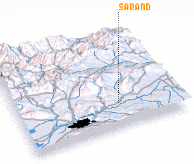 Places with similar names to Sarand, Iran ::
Disclaimer :: Information on this page comes without warranty of any kind |
||
|
Where is Sarand? Elevation and coordinates ::
Latitude (lat): 38°16'25"N Longitude (lon): 46°38'19"E
Elevation (approx.): 1885m (map arrows pan, magnifying glasses zoom) |
||
|
Visiting Sarand? Hotel/Accommodation ::
Book a hotel in Sarand Travel Guide ::
Buy a travel guide for Iran rental cars ::
car rental offers GPS waypoint ::
download a GPX waypoint (PoI) of Sarand for your GPS receiver
|
||