|
search place name
|
||
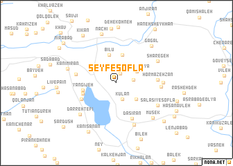
Seyf-e Soflá (Kordestān, Iran)Seyf-e Soflá is a town in the Kordestān region of Iran. An overview map of the region around Seyf-e Soflá is displayed below.
regional and 3d topo map of Seyf-e Soflá, Iran ::
Seyf-e Soflá airports ::
The nearest airport is SDG - Sanandaj, located 86.6 km south east of Seyf-e Soflá.
Other airports nearby include KSH - Bakhtaran Shahid Ashrafi Esfahani (165.3 km south east), Nearby towns ::
Moḩammadeh (1.6km north) //
Faqeh Yūsof (2.2km east) //
Kūlān (2.7km south) //
Seyf-e ‘Olyā (3.2km north east) //
Chāvak (3.7km south east) //
Benāvcheleh (4.6km north) //
Bīlū (4.6km north) //
Yangījeh (4.5km west) //
Kānī Sefīd (4.7km west) //
Pīr Şafā (5.3km south west) //
Dāsīrān (6.1km south) //
Hormazeh Zān (5.4km east) //
Bardeh Rasheh (5.5km west) //
Pīleh (5.9km east) //
Marīvān (7.1km south) //
Sharegeh (6.4km north east) //
Salasī-ye ‘Olyā (6.1km east) //
Salasī-ye Soflá (6.5km south east) //
Darreh Tefī (6.9km south west) //
Mūsek (7.4km south east) //
Kānī Mīrān (6.8km west) //
Gāgal (7.5km north east) //
Nachī (8.1km north) //
Darrehvarān (8.7km north) //
Kānī Sānān (8.7km south west) //
Kīkan (8.8km north west) //
Tāzehābād (8.8km south east) //
Hāneh Sheykhān (10.0km north east) //
Mīrābād (9.5km north west) //
[all distances 'as the bird flies' and approximate]  Places with similar names to Seyf-e Soflá, Iran :: Disclaimer :: Information on this page comes without warranty of any kind |
||
|
Where is Seyf-e Soflá? Elevation and coordinates ::
Latitude (lat): 35°34'57"N Longitude (lon): 46°8'57"E
Elevation (approx.): 1453m (map arrows pan, magnifying glasses zoom) |
||
|
Visiting Seyf-e Soflá? Hotel/Accommodation ::
Book a hotel in Seyf-e Soflá Travel Guide ::
Buy a travel guide for Iran rental cars ::
car rental offers GPS waypoint ::
download a GPX waypoint (PoI) of Seyf-e Soflá for your GPS receiver
|
||