|
search place name
|
||
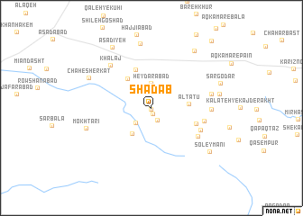
Shādāb (Khorāsān, Iran)Shādāb is a town in the Khorāsān region of Iran. An overview map of the region around Shādāb is displayed below.
regional and 3d topo map of Shādāb, Iran ::
Nearby towns ::
Kārīz Sabz (0.2km south) //
Zarkak (0.8km south) //
Qal‘eh Now (1.7km south) //
Kat Kārīz (2.4km south west) //
Ḩeydarābād (3.1km north) //
Nasar (3.8km south west) //
Altātū (3.8km east) //
Fashrābād (4.4km north west) //
Qosh Robāţ (5.0km north) //
Āqā Bīl-e Bālā (4.9km south east) //
Senjedak (5.7km south east) //
Chahār Derakht (5.8km south east) //
Āqā Bīl-e Pā'īn (5.6km east) //
Khalaj (6.7km north west) //
Beh Sūz (6.0km east) //
Mīān Dehī (6.3km east) //
Aḩmadābād-e Khazā'ī (8.0km north) //
Mokhtārī (7.0km west) //
Mīr Moḩammad (7.1km east) //
Chāh-e Sherkat (7.4km north west) //
Kalāteh-ye Khūnī (8.3km north east) //
Asadīyeh (8.5km north west) //
Soleymānī (7.9km south east) //
Sar Godār (7.6km north east) //
Cheshmeh Golek-e Pā'īn (10.3km north east) //
[all distances 'as the bird flies' and approximate]  Places with similar names to Shādāb, Iran ::
Disclaimer :: Information on this page comes without warranty of any kind |
||
|
Where is Shādāb? Elevation and coordinates ::
Latitude (lat): 35°33'5"N Longitude (lon): 59°28'0"E
Elevation (approx.): 1786m (map arrows pan, magnifying glasses zoom) |
||
|
Visiting Shādāb? Hotel/Accommodation ::
Book a hotel in Shādāb Travel Guide ::
Buy a travel guide for Iran rental cars ::
car rental offers GPS waypoint ::
download a GPX waypoint (PoI) of Shādāb for your GPS receiver
|
||