|
search place name
|
||
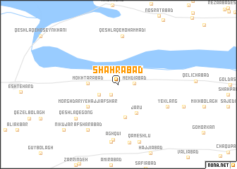
Shahrābād (Tehrān, Iran)Shahrābād is a town in the Tehrān region of Iran. An overview map of the region around Shahrābād is displayed below.
regional and 3d topo map of Shahrābād, Iran ::
Shahrābād airports ::
The nearest airport is THR - Teheran Mehrabad Intl, located 72.8 km east of Shahrābād.
Other airports nearby include RZR - Ramsar (131.6 km north), RAS - Rasht (194.5 km north west), Nearby towns ::
Shāh Bak (1.9km south west) //
Fardābād (1.9km south west) //
Mehdīābād (2.0km east) //
Gāvdārī-ye Shāh Bak (3.0km south west) //
Mokhtārābād (4.0km west) //
Būja‘far (5.3km south) //
Jārū (5.1km south east) //
Morghdārī-ye Ḩājjī Afshār (5.3km south west) //
Qeshlāq-e Moḩammadī (7.6km north) //
Yek Lang (7.2km south east) //
Qeshlāq-e Gong (7.7km south west) //
Afshārābād (8.3km south west) //
Āgh Qū'ī (8.8km south) //
Nīkūjār (10.1km south west) //
[all distances 'as the bird flies' and approximate] 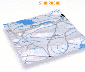 Places with similar names to Shahrābād, Iran ::
// Chārābād (IR)
// Chehrābād (IR)
// Cherāghābād (IR)
// Cherāghābād (IR)
// Cherāghābād (IR)
// Cherāghābād (IR)
// Cherāghābād (IR)
// Cherāghābād (IR)
// Cherāghābād (IR)
// Cherāghābād (IR)
Disclaimer :: Information on this page comes without warranty of any kind |
||
|
Where is Shahrābād? Elevation and coordinates ::
Latitude (lat): 35°43'54"N Longitude (lon): 50°30'39"E
Elevation (approx.): 1146m (map arrows pan, magnifying glasses zoom) |
||
|
Visiting Shahrābād? Hotel/Accommodation ::
Book a hotel in Shahrābād Travel Guide ::
Buy a travel guide for Iran rental cars ::
car rental offers GPS waypoint ::
download a GPX waypoint (PoI) of Shahrābād for your GPS receiver
|
||