|
search place name
|
||
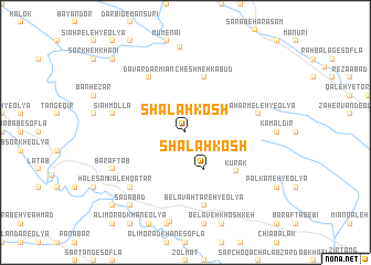
Shalah Kosh (Īlām, Iran)Shalah Kosh is a town in the Īlām region of Iran. An overview map of the region around Shalah Kosh is displayed below.
regional and 3d topo map of Shalah Kosh, Iran ::
Shalah Kosh airports ::
The nearest airport is KSH - Bakhtaran Shahid Ashrafi Esfahani, located 74.6 km north east of Shalah Kosh.
Other airports nearby include SDG - Sanandaj (167.2 km north), Nearby towns ::
Shalah Kosh (4.0km south east) //
Cheshmeh Kabūd (5.8km north) //
Kūrak (5.8km south east) //
Davār Dar Mīān (6.4km north west) //
Sīāh Mollā (6.4km west) //
Belāvah Tareh-ye ‘Olyā (7.6km south) //
Chahār Meleh-ye ‘Olyā (6.4km east) //
Kaleh Qaţār (7.2km south west) //
Barāftāb (7.2km south west) //
Mīān Choqā (8.6km north) //
Ţāq Gāvarīn (8.7km south west) //
Kal-e Qaţār-e ‘Olyā (8.7km south west) //
Sa‘dābād (8.7km south west) //
Sīāh Peleh-ye Soflá (9.6km north west) //
Qāsemābād (9.6km south west) //
[all distances 'as the bird flies' and approximate] 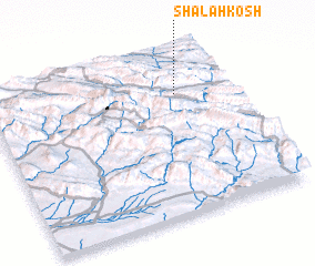 Places with similar names to Shalah Kosh, Iran ::
Disclaimer :: Information on this page comes without warranty of any kind |
||
|
Where is Shalah Kosh? Elevation and coordinates ::
Latitude (lat): 33°45'0"N Longitude (lon): 46°47'0"E
Elevation (approx.): 1445m (map arrows pan, magnifying glasses zoom) |
||
|
Visiting Shalah Kosh? Hotel/Accommodation ::
Book a hotel in Shalah Kosh Travel Guide ::
Buy a travel guide for Iran rental cars ::
car rental offers GPS waypoint ::
download a GPX waypoint (PoI) of Shalah Kosh for your GPS receiver
|
||