|
search place name
|
||
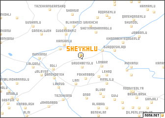
Sheykhlū (Kermān, Iran)Sheykhlū is a town in the Kermān region of Iran. An overview map of the region around Sheykhlū is displayed below.
regional and 3d topo map of Sheykhlū, Iran ::
Sheykhlū airports ::
The nearest airport is TBZ - Tabriz Intl, located 147.7 km west of Sheykhlū.
Other airports nearby include RAS - Rasht (208.0 km south east), Nearby towns ::
Chapaqān (0.6km north) //
Barāzmand (1.9km south) //
Dadeh Beyglū (1.9km south) //
Fakhrābād (4.5km south) //
Lombar (3.9km south east) //
Qāderlū (4.1km north east) //
Kangarlū (4.5km north west) //
Chang Darreh (4.5km north west) //
Arjaq (5.0km south east) //
Lārī (5.8km south) //
Gūdeh Kahrīz (6.3km north west) //
Leḩāq (5.7km south east) //
Sheykh Moḩammadlū (6.6km north) //
Adlī (5.6km south west) //
‘Ālī Kahrīzī (7.6km north) //
Davehchī (7.6km north) //
Ojāq Qeshlāqī (6.1km east) //
Qareh Qayeh (6.7km south west) //
Mīr ‘Alīlū (7.1km south east) //
Chakhmāq Chokūr (7.5km north west) //
Lāhrūd (7.7km south west) //
Alvār (8.5km south) //
Kavīch (9.4km south east) //
[all distances 'as the bird flies' and approximate]  Places with similar names to Sheykhlū, Iran ::
Disclaimer :: Information on this page comes without warranty of any kind |
||
|
Where is Sheykhlū? Elevation and coordinates ::
Latitude (lat): 38°34'0"N Longitude (lon): 47°50'0"E
Elevation (approx.): 1024m (map arrows pan, magnifying glasses zoom) |
||
|
Visiting Sheykhlū? Hotel/Accommodation ::
Book a hotel in Sheykhlū Travel Guide ::
Buy a travel guide for Iran rental cars ::
car rental offers GPS waypoint ::
download a GPX waypoint (PoI) of Sheykhlū for your GPS receiver
|
||