|
search place name
|
||
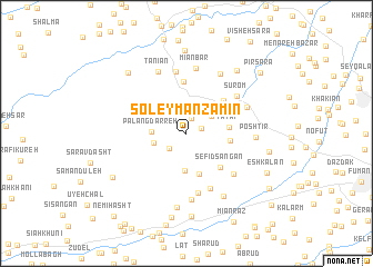
Soleymān Zamīn (Gīlān, Iran)Soleymān Zamīn is a town in the Gīlān region of Iran. An overview map of the region around Soleymān Zamīn is displayed below.
regional and 3d topo map of Soleymān Zamīn, Iran ::
Soleymān Zamīn airports ::
The nearest airport is RAS - Rasht, located 40.6 km east of Soleymān Zamīn.
Other airports nearby include RZR - Ramsar (141.3 km east), Nearby towns ::
Sīāh Kūh (1.3km east) //
Sīāhvarūd (1.6km north) //
Latīmpūrd (2.0km south west) //
Tūseh Kelh (2.7km north east) //
Chāleksar (3.0km north east) //
Kīsh Darreh (2.8km west) //
Palang Darreh (2.8km west) //
Gāvkūh (3.7km south) //
Teymūr Kūh (4.2km south) //
Taţaf (3.5km east) //
Seh Sār (3.6km east) //
Sefīd Sangān (4.4km south east) //
Mahvīzān (4.4km north east) //
Raftekeh (5.2km north) //
Taţaf Rūd-e Ālīān (5.9km south) //
Koltān Sar (6.1km south) //
Shālkūh (5.5km south east) //
Kīsheh Khānī (6.2km north) //
Sūrom (5.5km north east) //
Gūrāb Zarmakh (5.5km north east) //
Mīānbar (6.6km north) //
Masjed Pīsh (6.7km south) //
Tanīān (6.6km north) //
Posht Mekh (6.5km north east) //
Poshtīr (5.5km east) //
Khajkeh (6.9km south east) //
‘Abbās Kūh (7.4km south) //
Nadāmān (7.5km north east) //
Mehdīkhān Maḩalleh (8.3km north) //
[all distances 'as the bird flies' and approximate]  Places with similar names to Soleymān Zamīn, Iran :: Disclaimer :: Information on this page comes without warranty of any kind |
||
|
Where is Soleymān Zamīn? Elevation and coordinates ::
Latitude (lat): 37°16'2"N Longitude (lon): 49°9'14"E
Elevation (approx.): 146m (map arrows pan, magnifying glasses zoom) |
||
|
Visiting Soleymān Zamīn? Hotel/Accommodation ::
Book a hotel in Soleymān Zamīn Travel Guide ::
Buy a travel guide for Iran rental cars ::
car rental offers GPS waypoint ::
download a GPX waypoint (PoI) of Soleymān Zamīn for your GPS receiver
|
||