|
search place name
|
||
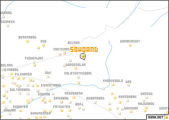
Sowqand (Khorāsān, Iran)Sowqand is a town in the Khorāsān region of Iran. An overview map of the region around Sowqand is displayed below.
regional and 3d topo map of Sowqand, Iran ::
Sowqand airports ::
The nearest airport is ASB - Ashkhabad Ashgabat, located 204.2 km north of Sowqand.
Nearby towns ::
Dārossalām (2.4km south west) //
Kalāteh-ye Tātār (2.6km west) //
Būzhān (3.5km north west) //
Kalāteh-ye Eqbāl (4.1km south) //
Būzhābād (3.8km north west) //
Dasht (3.8km west) //
Taḩt-e Manz̧ar (3.9km west) //
Būzh Mehrān (5.2km south) //
Ḩeşār (4.5km west) //
Kharv-e Pā'īn (7.3km south east) //
Kharv-e Bālā (7.5km south east) //
Ordūghesh (8.5km south) //
Adk (7.5km south west) //
Bāzeh Kalān (9.1km south east) //
‘Eshratābād (8.8km south west) //
Fīrūzī (9.4km south west) //
Najmābād (9.4km south west) //
Bāgh-e Ershādīyeh (10.1km south east) //
Kohnāb (11.2km south west) //
Ḩoseynābād-e Ghaffārī (11.2km south west) //
[all distances 'as the bird flies' and approximate] 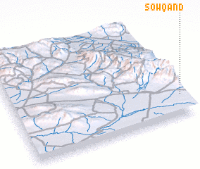 Places with similar names to Sowqand, Iran ::
Disclaimer :: Information on this page comes without warranty of any kind |
||
|
Where is Sowqand? Elevation and coordinates ::
Latitude (lat): 36°13'7"N Longitude (lon): 58°59'42"E
Elevation (approx.): 1716m (map arrows pan, magnifying glasses zoom) |
||
|
Visiting Sowqand? Hotel/Accommodation ::
Book a hotel in Sowqand Travel Guide ::
Buy a travel guide for Iran rental cars ::
car rental offers GPS waypoint ::
download a GPX waypoint (PoI) of Sowqand for your GPS receiver
|
||