|
search place name
|
||
Sūq (Ostān-e Kohgīlūyeh va Būyer Aḩmad, Iran)Sūq is a town in the Ostān-e Kohgīlūyeh va Būyer Aḩmad region of Iran. An overview map of the region around Sūq is displayed below.
regional and 3d topo map of Sūq, Iran ::

Sūq airports ::
The nearest airport is MRX - Bandar Mahshahr Mahshahr, located 129.4 km west of Sūq.
Other airports nearby include QMJ - Masjed Soleiman Shahid Asyaee (169.2 km north west), AWZ - Ahwaz (169.8 km west), BUZ - Bushehr (215.8 km south), Nearby towns ::
Darreh Dū‘ī (2.9km west) //
Nar Derāz (3.5km north west) //
Ābmū Soflá (3.5km south west) //
Līr-e Bozorg (4.1km north) //
Khalīfeh (4.3km east) //
Kūh-e Rāk (4.9km north east) //
Līr-e Kūchek (5.3km north) //
Borm-e Sabz (5.1km north west) //
Dezak (5.3km south east) //
Borm-e Shīr (6.0km north) //
Balūţ Bangān (5.8km south west) //
Changalvā (6.7km south) //
Rāk (6.3km north east) //
Āb Korī (7.5km north) //
Tagargī (7.8km north) //
Qal‘eh-ye Dozheh Kūh (7.4km north west) //
Bībī Zoleykhā'ī (8.6km north west) //
Kal (8.3km south east) //
Takht Derāz (9.8km north west) //
Cham Sīāh (9.9km south west) //
Chaghal (9.7km north east) //
Darreh Lak (10.3km south east) //
Godār Narkūn (10.8km south west) //
Pā'īn Kūh Pāt (11.4km north east) //
[all distances 'as the bird flies' and approximate] 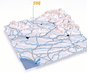 Places with similar names to Sūq, Iran ::
Disclaimer :: Information on this page comes without warranty of any kind |
||
|
Where is Sūq? Elevation and coordinates ::
Latitude (lat): 30°51'49"N Longitude (lon): 50°27'17"E
Elevation (approx.): 871m (map arrows pan, magnifying glasses zoom) |
||
|
Visiting Sūq? Hotel/Accommodation ::
Book a hotel in Sūq Travel Guide ::
Buy a travel guide for Iran rental cars ::
car rental offers GPS waypoint ::
download a GPX waypoint (PoI) of Sūq for your GPS receiver
|
||