|
search place name
|
||
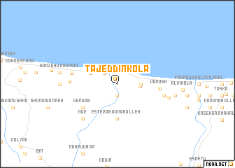
Tāj ed Dīn Kolā (Iran)Tāj ed Dīn Kolā is a town in Iran. An overview map of the region around Tāj ed Dīn Kolā is displayed below.
regional and 3d topo map of Tāj ed Dīn Kolā, Iran ::
Tāj ed Dīn Kolā airports ::
The nearest airport is THR - Teheran Mehrabad Intl, located 106.8 km south west of Tāj ed Dīn Kolā.
Other airports nearby include RZR - Ramsar (107.1 km west), Nearby towns ::
Mollā Kolā (1.9km south) //
Dīzer Kolā (1.9km south) //
Şalāh od Dīn Kolā-ye Soflá (2.4km north west) //
Tūskātok (2.4km north west) //
Şalaḩ od Dīn Kolā-ye ‘Olyā (2.9km east) //
Pey Kolā (3.0km east) //
‘Alīābād-e ‘Askarkhān (3.9km north west) //
Esterābād Maḩalleh (5.6km south) //
Gerdāb (5.8km south west) //
Vanūsh (5.5km east) //
Āndarvar (6.1km west) //
Kheẕr-e Tīreh (6.2km east) //
Pāshā Kolā (6.2km east) //
Sang Sarā (6.2km west) //
Mūr (7.1km south west) //
Nārenjbon (6.9km east) //
[all distances 'as the bird flies' and approximate]  Places with similar names to Tāj ed Dīn Kolā, Iran :: Disclaimer :: Information on this page comes without warranty of any kind |
||
|
Where is Tāj ed Dīn Kolā? Elevation and coordinates ::
Latitude (lat): 36°34'0"N Longitude (lon): 51°48'0"E
Elevation (approx.): 74m (map arrows pan, magnifying glasses zoom) |
||
|
Visiting Tāj ed Dīn Kolā? Hotel/Accommodation ::
Book a hotel in Tāj ed Dīn Kolā Travel Guide ::
Buy a travel guide for Iran rental cars ::
car rental offers GPS waypoint ::
download a GPX waypoint (PoI) of Tāj ed Dīn Kolā for your GPS receiver
|
||