|
search place name
|
||
Tang Rīs (Chahār Maḩāll va Bakhtīār, Iran)Tang Rīs is a town in the Chahār Maḩāll va Bakhtīār region of Iran. An overview map of the region around Tang Rīs is displayed below.
regional and 3d topo map of Tang Rīs, Iran ::

Tang Rīs airports ::
The nearest airport is QMJ - Masjed Soleiman Shahid Asyaee, located 185.0 km north west of Tang Rīs.
Other airports nearby include MRX - Bandar Mahshahr Mahshahr (187.0 km west), SYZ - Shiraz Shahid Dastghaib Intl (239.7 km south east), Nearby towns ::
Shablīz (4.0km north) //
Cheshmeh Derāz-e Delī Gerdū (5.1km south) //
Chamanbīd-e Delīgerdū (5.6km south) //
Ţalāyeh (6.1km north) //
Cheshmeh Rīzak-e Shablīz (6.1km south east) //
Talāyeh (6.1km north east) //
Tāksīseh-ye Soflá (6.1km south west) //
Tāksīseh-ye ‘Olyā (6.2km south west) //
Ātashgāh (6.6km north east) //
Sheykh Sarkeh (6.2km south west) //
Sar Qanāt-e Delī Gerdū (7.2km south) //
Varkow (6.7km north east) //
Mownowm (7.0km north east) //
Shūsh (7.7km north) //
Dūrak-e Ghāch (7.3km north east) //
Dehkadeh (7.4km east) //
Darreh Mīshūn (9.0km south east) //
Lah-e Mowlā'ī (9.6km south west) //
Javakār (10.7km south west) //
[all distances 'as the bird flies' and approximate] 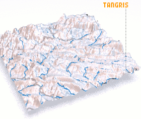 Places with similar names to Tang Rīs, Iran ::
// Dingras (PH)
// Tanacross (US)
// Dune Acres (US)
// Dawn Acres (US)
// Town Acres (US)
// Tengarissé (TD)
// Tankerys (KZ)
// Tonkeris (KZ)
// Tonkeris (KZ)
// Tonkeris (KZ)
Disclaimer :: Information on this page comes without warranty of any kind |
||
|
Where is Tang Rīs? Elevation and coordinates ::
Latitude (lat): 31°10'54"N Longitude (lon): 50°58'3"E
Elevation (approx.): 2638m (map arrows pan, magnifying glasses zoom) |
||
|
Visiting Tang Rīs? Hotel/Accommodation ::
Book a hotel in Tang Rīs Travel Guide ::
Buy a travel guide for Iran rental cars ::
car rental offers GPS waypoint ::
download a GPX waypoint (PoI) of Tang Rīs for your GPS receiver
|
||