|
search place name
|
||
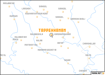
Tappeh Ḩamām (Īlām, Iran)Tappeh Ḩamām is a town in the Īlām region of Iran. An overview map of the region around Tappeh Ḩamām is displayed below.
regional and 3d topo map of Tappeh Ḩamām, Iran ::
Tappeh Ḩamām airports ::
The nearest airport is QMJ - Masjed Soleiman Shahid Asyaee, located 156.8 km south east of Tappeh Ḩamām.
Other airports nearby include AWZ - Ahwaz (173.2 km south east), KSH - Bakhtaran Shahid Ashrafi Esfahani (195.6 km north), Nearby towns ::
Kan-e Aḩmadkhān (3.1km east) //
Ābţāf (4.0km south east) //
Mūlāb (4.4km south west) //
Mūlāb-e Bālā (4.7km west) //
Charmel (5.0km east) //
Moḩammad-e Gheybī (5.8km south) //
Galhī (6.0km south east) //
Sīāh Gel (6.6km north) //
Chap Rāst (6.2km east) //
Pīātā Katkūl (7.3km south west) //
Ḩalīveh (8.3km north east) //
Rūdkhāneh-ye Sīāh Gāv (8.8km north west) //
[all distances 'as the bird flies' and approximate] 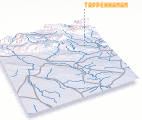 Places with similar names to Tappeh Ḩamām, Iran ::
// Tepu Mumba (ZM)
Disclaimer :: Information on this page comes without warranty of any kind |
||
|
Where is Tappeh Ḩamām? Elevation and coordinates ::
Latitude (lat): 32°40'0"N Longitude (lon): 47°48'0"E
Elevation (approx.): 339m (map arrows pan, magnifying glasses zoom) |
||
|
Visiting Tappeh Ḩamām? Hotel/Accommodation ::
Book a hotel in Tappeh Ḩamām Travel Guide ::
Buy a travel guide for Iran rental cars ::
car rental offers GPS waypoint ::
download a GPX waypoint (PoI) of Tappeh Ḩamām for your GPS receiver
|
||