|
search place name
|
||
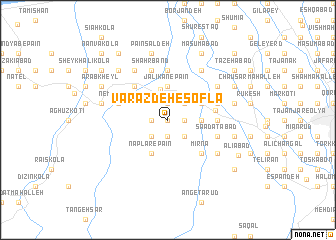
Varāzdeh-e Soflá (Iran)Varāzdeh-e Soflá is a town in Iran. An overview map of the region around Varāzdeh-e Soflá is displayed below.
regional and 3d topo map of Varāzdeh-e Soflá, Iran ::
Varāzdeh-e Soflá airports ::
The nearest airport is THR - Teheran Mehrabad Intl, located 116.5 km south west of Varāzdeh-e Soflá.
Other airports nearby include RZR - Ramsar (143.1 km west), Nearby towns ::
Qalā Kotī (0.0km north) //
Khaţīb Kolā (1.9km north) //
Rameshī (1.9km north) //
Belvīch (1.5km west) //
Varāzdeh-e ‘Olyā (1.9km south) //
Najāseb Kolā (1.5km east) //
Tūrān Kolā (1.5km east) //
Dār Kolā (1.5km east) //
Varāndeh (2.4km south west) //
Razak (2.4km north east) //
Meydān Sar (2.4km south east) //
Bārī Kolā (2.4km south east) //
Āhū Dasht (3.5km north) //
Jalīkān-e Pā'īn (3.7km north) //
Kīāb Sar (3.0km east) //
Kenespā (3.0km east) //
Tasbīḩ Kolā (3.0km east) //
Shahrak-e Emām Khomeynī (3.0km east) //
Nāplār-e Pā'īn (4.0km south) //
Būteh Deh (3.5km north east) //
Berīkolā (3.5km north east) //
Sangtāb (3.5km north east) //
Nāflār (4.0km south) //
Karatkatī (4.8km north west) //
Afrādeh (4.8km south east) //
Īrkā (4.8km south east) //
Mīrnā (4.8km south east) //
Jalīkān-e Bālā (4.4km east) //
Amīrābād (4.5km east) //
[all distances 'as the bird flies' and approximate]  Places with similar names to Varāzdeh-e Soflá, Iran :: Disclaimer :: Information on this page comes without warranty of any kind |
||
|
Where is Varāzdeh-e Soflá? Elevation and coordinates ::
Latitude (lat): 36°28'0"N Longitude (lon): 52°11'0"E
Elevation (approx.): 61m (map arrows pan, magnifying glasses zoom) |
||
|
Visiting Varāzdeh-e Soflá? Hotel/Accommodation ::
Book a hotel in Varāzdeh-e Soflá Travel Guide ::
Buy a travel guide for Iran rental cars ::
car rental offers GPS waypoint ::
download a GPX waypoint (PoI) of Varāzdeh-e Soflá for your GPS receiver
|
||