|
search place name
|
||
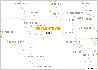
Veyleh-ye Yek (Ostān-e Kermānshāh, Iran)Veyleh-ye Yek is a town in the Ostān-e Kermānshāh region of Iran. An overview map of the region around Veyleh-ye Yek is displayed below.
regional and 3d topo map of Veyleh-ye Yek, Iran ::
Veyleh-ye Yek airports ::
The nearest airport is KSH - Bakhtaran Shahid Ashrafi Esfahani, located 82.4 km east of Veyleh-ye Yek.
Other airports nearby include SDG - Sanandaj (118.9 km north east), Nearby towns ::
Sartang (1.3km north east) //
Choqā Mīrgeh (2.2km south west) //
Deh Jāmī (3.4km north west) //
Deh-e Jāmī (3.4km north west) //
Rīsanī (4.2km west) //
Dāleh Hū (4.6km west) //
Dargah (6.5km north east) //
Darvīt (7.3km north) //
Deh Lafteh (6.3km west) //
Sheykh Ḩasan (6.8km north west) //
Tūt Shāmī (6.7km east) //
Harīr (8.2km south west) //
Kaneh Har (8.9km north west) //
Mohājerīn-e Qaşr-e Shīrīn (9.5km south west) //
[all distances 'as the bird flies' and approximate] 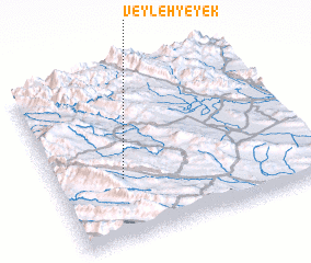 Places with similar names to Veyleh-ye Yek, Iran :: Disclaimer :: Information on this page comes without warranty of any kind |
||
|
Where is Veyleh-ye Yek? Elevation and coordinates ::
Latitude (lat): 34°22'5"N Longitude (lon): 46°15'46"E
Elevation (approx.): 1620m (map arrows pan, magnifying glasses zoom) |
||
|
Visiting Veyleh-ye Yek? Hotel/Accommodation ::
Book a hotel in Veyleh-ye Yek Travel Guide ::
Buy a travel guide for Iran rental cars ::
car rental offers GPS waypoint ::
download a GPX waypoint (PoI) of Veyleh-ye Yek for your GPS receiver
|
||