|
search place name
|
||
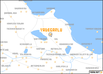
Yādegārlū (Ostān-e Āz̄arbāyjān-e Gharbī, Iran)Yādegārlū is a town in the Ostān-e Āz̄arbāyjān-e Gharbī region of Iran. An overview map of the region around Yādegārlū is displayed below.
regional and 3d topo map of Yādegārlū, Iran ::
Yādegārlū airports ::
The nearest airport is TBZ - Tabriz Intl, located 137.6 km north east of Yādegārlū.
Other airports nearby include SDG - Sanandaj (239.5 km south east), Nearby towns ::
Gūl (2.4km south east) //
Bārānī-ye Kord (2.4km south west) //
Bārānī-ye ‘Ajam (2.4km south west) //
Ḩasanlū (2.7km south west) //
Sheykh Aḩmad (3.5km south west) //
Moḩammad Yār (5.3km south) //
Āqţavīleh (5.8km south) //
Moḩammad Yār (5.8km south east) //
Shatqār (6.3km south west) //
Zīnehvar (6.4km north east) //
Tāzeh Kand-e Bolbol (7.6km south) //
Āqā Beyglū (8.0km south) //
Amīnlū (7.0km south west) //
Ḩājjībāghlū (7.0km south west) //
Ḩeydarābād (8.6km north west) //
Darakeh-ye Oros Khān (9.5km south east) //
[all distances 'as the bird flies' and approximate] 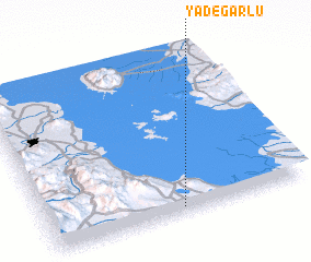 Places with similar names to Yādegārlū, Iran :: Disclaimer :: Information on this page comes without warranty of any kind |
||
|
Where is Yādegārlū? Elevation and coordinates ::
Latitude (lat): 37°2'0"N Longitude (lon): 45°31'0"E
Elevation (approx.): 1285m (map arrows pan, magnifying glasses zoom) |
||
|
Visiting Yādegārlū? Hotel/Accommodation ::
Book a hotel in Yādegārlū Travel Guide ::
Buy a travel guide for Iran rental cars ::
car rental offers GPS waypoint ::
download a GPX waypoint (PoI) of Yādegārlū for your GPS receiver
|
||