|
search place name
|
||
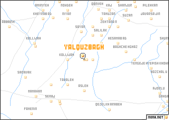
Yalqūz Bāgh (Hamadān, Iran)Yalqūz Bāgh is a town in the Hamadān region of Iran. An overview map of the region around Yalqūz Bāgh is displayed below.
regional and 3d topo map of Yalqūz Bāgh, Iran ::
Yalqūz Bāgh airports ::
The nearest airport is KSH - Bakhtaran Shahid Ashrafi Esfahani, located 200.1 km south west of Yalqūz Bāgh.
Other airports nearby include RZR - Ramsar (238.1 km north east), Nearby towns ::
Akleh (0.0km north) //
Haryān (0.5km east) //
Galleh Sar (1.5km east) //
Kollījah (3.0km west) //
Dehlaq (4.8km north east) //
Rakīn (5.8km north) //
Sāyān (6.3km north) //
Ţavāleh (6.3km south west) //
Salīlak (6.3km north east) //
Aşleh (6.9km south) //
Boḩkandān (7.6km north) //
Ḩesāmābād (7.1km north east) //
Ḩājjīābād (8.2km south west) //
Malīlak (8.7km north east) //
Zehtarān (8.7km north east) //
Mesīnak (9.6km north east) //
[all distances 'as the bird flies' and approximate] 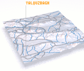 Places with similar names to Yalqūz Bāgh, Iran :: Disclaimer :: Information on this page comes without warranty of any kind |
||
|
Where is Yalqūz Bāgh? Elevation and coordinates ::
Latitude (lat): 35°12'0"N Longitude (lon): 49°5'0"E
Elevation (approx.): 1687m (map arrows pan, magnifying glasses zoom) |
||
|
Visiting Yalqūz Bāgh? Hotel/Accommodation ::
Book a hotel in Yalqūz Bāgh Travel Guide ::
Buy a travel guide for Iran rental cars ::
car rental offers GPS waypoint ::
download a GPX waypoint (PoI) of Yalqūz Bāgh for your GPS receiver
|
||