|
search place name
|
||
Yūnesābād (Iran)Yūnesābād is a town in Iran. An overview map of the region around Yūnesābād is displayed below.
regional and 3d topo map of Yūnesābād, Iran ::
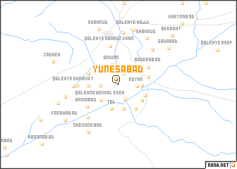
Nearby towns ::
Qal‘eh Şeddīq (1.9km north) //
Qal‘eh-ye Mehdī (2.5km south) //
Asadābād (2.3km west) //
Rūyān (2.4km east) //
Ardīān (3.2km north) //
Moghān (3.2km north west) //
Qal‘eh Now-e Khāleşeh (3.4km south west) //
Ja‘farābād (3.0km east) //
Kalāābād (3.9km south) //
Tal (3.9km south) //
Qal‘eh-ye Ḩasan Raḩmān (3.9km south) //
Ḩoseynābād-e Sāgharī (3.9km south east) //
Ḩoseynābād-e Zīrestāq (3.8km south east) //
Qal‘eh-ye Sāgharī (4.4km south east) //
Reẕāābād (3.8km west) //
Dīzej (4.0km east) //
Qal‘eh-ye Ḩāj Ţāher (4.2km north west) //
Bāqerābād (4.7km north east) //
Amīrābād (5.4km south west) //
Qal‘eh-ye Nowrūz Khān (6.2km north) //
Qal‘eh-ye ‘Aẕodī (5.3km west) //
Qāsemābād (6.5km south west) //
Qal‘eh-ye Showkat (5.7km west) //
Mehdīābād (7.0km north east) //
Bāgh-e Zendān (8.2km north) //
Shāhrūd (8.2km north east) //
Qal‘eh-ye Dowlat (7.1km west) //
Shekārābād (8.4km south west) //
Qal‘eh-ye Ḩājjī (8.9km north) //
[all distances 'as the bird flies' and approximate] 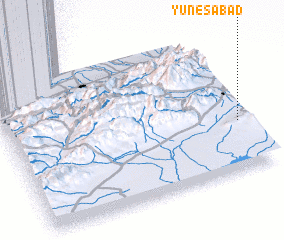 Places with similar names to Yūnesābād, Iran ::
Disclaimer :: Information on this page comes without warranty of any kind |
||
|
Where is Yūnesābād? Elevation and coordinates ::
Latitude (lat): 36°21'4"N Longitude (lon): 54°58'33"E
Elevation (approx.): 1250m (map arrows pan, magnifying glasses zoom) |
||
|
Visiting Yūnesābād? Hotel/Accommodation ::
Book a hotel in Yūnesābād Travel Guide ::
Buy a travel guide for Iran rental cars ::
car rental offers GPS waypoint ::
download a GPX waypoint (PoI) of Yūnesābād for your GPS receiver
|
||