|
search place name
|
||
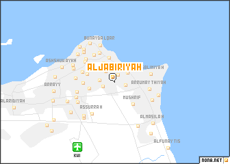
Al Jābirīyah (Al Wafrah, Kuwait)Al Jābirīyah is a town in the Al Wafrah region of Kuwait. An overview map of the region around Al Jābirīyah is displayed below.
regional and 3d topo map of Al Jābirīyah, Kuwait ::
Al Jābirīyah airports ::
The nearest airport is KWI - Kuwait Intl, located 11.9 km south west of Al Jābirīyah.
Other airports nearby include ABD - Abadan (117.9 km north), BSR - Basrah Intl (140.4 km north), MRX - Bandar Mahshahr Mahshahr (174.9 km north east), AQI - Hafr Al-batin Qaisumah (215.2 km south west), Nearby towns ::
Ḩawallī (1.3km north) //
Bayān (1.6km east) //
Ar Rawḑah (1.8km south west) //
An Nuqrah (2.1km north west) //
Ar Rawḑah (2.2km west) //
Sharq Ḩawallī (2.4km north east) //
Ash Sha‘b (2.8km north) //
Al Qādisīyah (3.5km north west) //
Ad Da‘īyah (4.1km north) //
An Nuzhah (3.9km north west) //
Qurţubah (3.9km west) //
Al Ḩadīqah (4.1km west) //
Ad Da‘īyah (4.1km west) //
Mushrif (4.5km south east) //
Al Qādisīyah (4.7km north west) //
Al ‘Adīlīyah (4.5km west) //
Ad Dasmah (5.2km north west) //
Al Fayḩāʼ (4.9km west) //
Umm Şiddah (5.3km north west) //
Ar Rumaythīyah (5.0km east) //
Ḑāhiyat ‘Abd Allāh as Sālim (5.3km north west) //
As Sālimīyah (5.3km east) //
Al Manşūrīyah (5.6km north west) //
Bunayd al Qār (6.3km north) //
As Surrah (6.2km south west) //
Al Yarmūk (5.7km west) //
Al Khālidīyah (5.7km west) //
Salwá (6.1km south east) //
Al ‘Udaylīyah (6.0km south west) //
[all distances 'as the bird flies' and approximate]  Places with similar names to Al Jābirīyah, Kuwait ::
// Al Jābirīyah (EG)
// AL Jābirīyah (SA)
// Al Jābirīyah (SA)
// Al Jābirīyah (SA)
// Al Jabrīyah (SA)
// Al Jabrīyah (SA)
// Al Jābirīyah (SY)
// Al Jubayrīyah (YE)
// Al Jabarīyah (YE)
// AL Jābūrīyah (YE)
Disclaimer :: Information on this page comes without warranty of any kind |
||
|
Where is Al Jābirīyah? Elevation and coordinates ::
Latitude (lat): 29°19'20"N Longitude (lon): 48°1'25"E
Elevation (approx.): 23m (map arrows pan, magnifying glasses zoom) |
||
|
Visiting Al Jābirīyah? Hotel/Accommodation ::
Book a hotel in Al Jābirīyah Travel Guide ::
Buy a travel guide for Kuwait rental cars ::
car rental offers GPS waypoint ::
download a GPX waypoint (PoI) of Al Jābirīyah for your GPS receiver
|
||