|
search place name
|
||
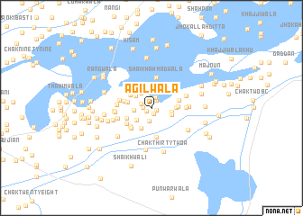
Agilwāla (Punjab, Pakistan)Agilwāla is a town in the Punjab region of Pakistan. An overview map of the region around Agilwāla is displayed below.
regional and 3d topo map of Agilwāla, Pakistan ::
Agilwāla airports ::
The nearest airport is MUX - Multan Intl, located 95.5 km north west of Agilwāla.
Other airports nearby include RYK - Rahim Yar Khan Sheikh Zayed (193.1 km south west), LYP - Faisalabad Intl (240.3 km north east), Nearby towns ::
Fāzalwāli (0.6km south east) //
Dubba (0.7km south west) //
Kumhārānwāli (0.8km south) //
Lāle Dera (0.9km north) //
Bakhshewāla (0.9km west) //
Phaurānwāli (1.1km north east) //
Jandiwāli (1.2km north west) //
Utla Dera (1.4km north) //
Pānuwāla (1.7km south) //
Dera Bakha (2.0km north) //
BastiNūrūwāli (1.9km west) //
Doharta (2.1km north west) //
Māri Qāsim Shāh (2.2km north west) //
Kālewāla (2.2km south west) //
Sahwān (2.3km north west) //
Chak Thirty-six (2.2km east) //
Jāman Khānwāli (2.3km east) //
Chak Four (2.8km south west) //
Mullānwāli (2.6km west) //
Mānkewāla (2.8km north west) //
Hassan Shāhwāla (2.7km east) //
Tārāgarh (2.9km east) //
Nawān Khu (3.0km south west) //
Basti Jarād (3.2km south west) //
Gulpur (3.1km west) //
Chak Thirty (3.3km south west) //
Jān Muhammadwāla (3.2km east) //
Hassanwāla (3.3km south west) //
Chak Thirty-two (3.7km south) //
[all distances 'as the bird flies' and approximate]  Places with similar names to Agilwāla, Pakistan ::
// Awjlahwāla (PK)
Disclaimer :: Information on this page comes without warranty of any kind |
||
|
Where is Agilwāla? Elevation and coordinates ::
Latitude (lat): 29°25'58"N Longitude (lon): 71°51'40"E
Elevation (approx.): 120m (map arrows pan, magnifying glasses zoom) |
||
|
Visiting Agilwāla? Hotel/Accommodation ::
Book a hotel in Agilwāla Travel Guide ::
Buy a travel guide for Pakistan rental cars ::
car rental offers GPS waypoint ::
download a GPX waypoint (PoI) of Agilwāla for your GPS receiver
|
||