|
search place name
|
||
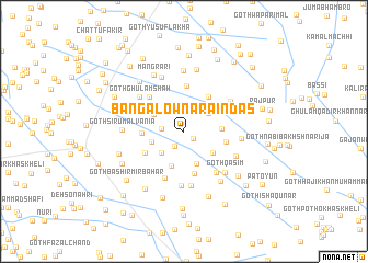
Bangalow Nārāindas (Sind, Pakistan)Bangalow Nārāindas is a town in the Sind region of Pakistan. An overview map of the region around Bangalow Nārāindas is displayed below.
regional and 3d topo map of Bangalow Nārāindas, Pakistan ::
Bangalow Nārāindas airports ::
The nearest airport is WNS - Nawabshah, located 68.7 km north west of Bangalow Nārāindas.
Other airports nearby include BDN - Talhar (106.2 km south), MJD - Moenjodaro (186.0 km north west), KHI - Karachi Jinnah Intl (200.5 km south west), SKZ - Sukkur (213.4 km north), Nearby towns ::
Goth Jaryo Bhambhro (1.1km south east) //
Goth Darya Khān Khoso (1.8km south west) //
Berwāri (2.1km north) //
Goth Sājan Wasān (2.1km west) //
Goth Ghafūr Wasān (2.4km north) //
Goth Sādiq Wasān (2.9km north east) //
Goth Hāji Bachal Khoso (3.0km south west) //
Goth Gullu Meghwār (3.1km west) //
Goth Bachi Khoso (3.4km south) //
Jamīhtra (3.3km north west) //
Goth Sāhib Khān (3.4km south east) //
Goth Jaryo Khoso (3.7km south) //
Goth Allāh Warāya Māchhi (3.5km east) //
Goth Dīno Wasān (3.9km west) //
Goth Tapāli (4.2km north east) //
Goth Abdul Mālik Baloch (4.0km east) //
Goth Dīno Joneja (4.4km south) //
Goth Nawāb Jām Nawāz Ali Khān (4.2km south west) //
Goth Jān Muhammad Wasān (4.6km north) //
Goth Chāndio (4.8km north west) //
Goth Hāji Khoso (5.1km south) //
Goth Nāga Bhīl (5.1km south east) //
Kaisar Khān Marri (4.9km north west) //
Goth Hāji Qaisar Khān (5.6km south) //
Goth Mittho Māchhi (5.6km south) //
Goth Atta Muhammad (5.3km north east) //
Goth Ghulam Shāh (5.4km north west) //
Goth Manthār Janeja (5.3km south east) //
Goth Qāsim (5.6km south east) //
[all distances 'as the bird flies' and approximate]  Places with similar names to Bangalow Nārāindas, Pakistan :: Disclaimer :: Information on this page comes without warranty of any kind |
||
|
Where is Bangalow Nārāindas? Elevation and coordinates ::
Latitude (lat): 25°47'55"N Longitude (lon): 68°53'40"E
Elevation (approx.): 20m (map arrows pan, magnifying glasses zoom) |
||
|
Visiting Bangalow Nārāindas? Hotel/Accommodation ::
Book a hotel in Bangalow Nārāindas Travel Guide ::
Buy a travel guide for Pakistan rental cars ::
car rental offers GPS waypoint ::
download a GPX waypoint (PoI) of Bangalow Nārāindas for your GPS receiver
|
||