|
search place name
|
||
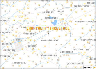
Chak Twenty-three-Two L (Punjab, Pakistan)Chak Twenty-three-Two L is a town in the Punjab region of Pakistan. An overview map of the region around Chak Twenty-three-Two L is displayed below.
regional and 3d topo map of Chak Twenty-three-Two L, Pakistan ::
Chak Twenty-three-Two L airports ::
The nearest airport is LYP - Faisalabad Intl, located 78.4 km north west of Chak Twenty-three-Two L.
Other airports nearby include LHE - Lahore Allama Iqbal Intl (110.4 km north east), ATQ - Amritsar (152.4 km north east), IXJ - Jammu (237.9 km north east), Nearby towns ::
Chak Twenty-four-Two L (2.3km south west) //
Chak Fifteen-One L (2.5km south east) //
Doārsābād (3.3km north) //
Chak Fourteen-One L (3.4km south) //
Chak Twenty-four-Two R (3.1km north west) //
Chak Twenty-one-Two L (3.3km north east) //
Chak Sixteen-One L (3.8km east) //
Chak Thirteen-One L (4.6km south) //
Kharar Lāhauri Chandwāla (4.6km north west) //
Chak Eleven-One L (4.7km south east) //
Chak Twenty-six-Two R (4.4km west) //
Chak Twelve-One L (5.1km south) //
Lewispur (5.2km north) //
Renāla Kalān (5.4km north) //
Kot Walia (4.9km east) //
Chak Twenty-six-Two L (5.1km south west) //
Chak Twenty-seven-Two L (5.6km south west) //
Dholan Shāh (5.5km north west) //
Chak Ten-One L (5.8km south east) //
Mānakwāla (6.3km north) //
Renāla Khurd (6.1km north east) //
Chak Twenty-eight-Two L (6.5km south west) //
Mallarpur (5.9km west) //
Chak Nine-One L (6.7km south east) //
Rahna Bhūrewāla (6.9km south) //
Chak Eighteen-One L (6.0km east) //
Sri Rāmnagar (6.3km west) //
Chak Twenty-One L (6.4km north east) //
Maingahwāh (6.3km west) //
[all distances 'as the bird flies' and approximate]  Places with similar names to Chak Twenty-three-Two L, Pakistan :: Disclaimer :: Information on this page comes without warranty of any kind |
||
|
Where is Chak Twenty-three-Two L? Elevation and coordinates ::
Latitude (lat): 30°50'45"N Longitude (lon): 73°33'10"E
Elevation (approx.): 182m (map arrows pan, magnifying glasses zoom) |
||
|
Visiting Chak Twenty-three-Two L? Hotel/Accommodation ::
Book a hotel in Chak Twenty-three-Two L Travel Guide ::
Buy a travel guide for Pakistan rental cars ::
car rental offers GPS waypoint ::
download a GPX waypoint (PoI) of Chak Twenty-three-Two L for your GPS receiver
|
||