|
search place name
|
||
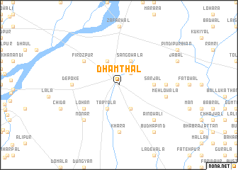
Dhamthal (Punjab, Pakistan)Dhamthal is a town in the Punjab region of Pakistan. An overview map of the region around Dhamthal is displayed below.
regional and 3d topo map of Dhamthal, Pakistan ::
Dhamthal airports ::
The nearest airport is IXJ - Jammu, located 47.2 km north of Dhamthal.
Other airports nearby include ATQ - Amritsar (62.5 km south), IXP - Pathankot (69.3 km east), LHE - Lahore Allama Iqbal Intl (95.0 km south west), LUH - Ludhiaha Ludhiana (185.7 km south east), Nearby towns ::
Sohiān (2.4km north east) //
Sangowāla (4.0km north east) //
Munde Bājwe (4.0km north west) //
Sankhatra (4.0km south east) //
Tapyāla (4.0km south west) //
Sarjāl (4.7km east) //
Fīrozpur (6.0km north west) //
Lohān (6.0km south west) //
Sathiāla (6.3km east) //
Sangiāl (6.3km east) //
Khāra (7.4km south) //
Depoke (6.3km west) //
Mehlowāla (6.5km east) //
Ainowāli (7.3km south east) //
Nonar (7.3km south west) //
Budha Pind (8.8km south east) //
[all distances 'as the bird flies' and approximate] 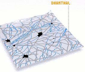 Places with similar names to Dhamthal, Pakistan ::
// Dhamthāl (PK)
Disclaimer :: Information on this page comes without warranty of any kind |
||
|
Where is Dhamthal? Elevation and coordinates ::
Latitude (lat): 32°16'0"N Longitude (lon): 74°54'0"E
Elevation (approx.): 259m (map arrows pan, magnifying glasses zoom) |
||
|
Visiting Dhamthal? Hotel/Accommodation ::
Book a hotel in Dhamthal Travel Guide ::
Buy a travel guide for Pakistan rental cars ::
car rental offers GPS waypoint ::
download a GPX waypoint (PoI) of Dhamthal for your GPS receiver
|
||