|
search place name
|
||
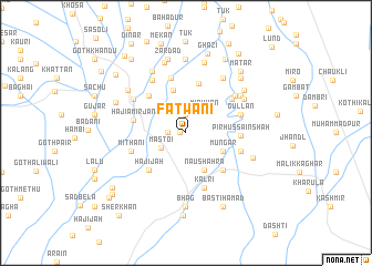
Fatwāni (Balochistān, Pakistan)Fatwāni is a town in the Balochistān region of Pakistan. An overview map of the region around Fatwāni is displayed below.
regional and 3d topo map of Fatwāni, Pakistan ::
Fatwāni airports ::
The nearest airport is SUL - Sui, located 142.0 km east of Fatwāni.
Other airports nearby include UET - Quetta (153.4 km north west), SKZ - Sukkur (180.1 km south east), MJD - Moenjodaro (198.2 km south), Nearby towns ::
Tiār Ghāzi (0.5km west) //
Gauhrāni (1.9km north) //
Pahor Kalān (1.6km west) //
Mīr Khān (2.7km north east) //
Mastoi (2.7km south west) //
Naushahra (4.0km south east) //
Mungar (3.7km south east) //
Āmānu (4.5km north) //
Khokhar Bangulzai (5.1km north) //
Hadwār (4.9km south east) //
Goth Khudādād (4.9km north west) //
Hājijāh (4.9km south west) //
Hāji Amīr Jān (4.8km west) //
Pīr Hussain Shāh (4.9km east) //
Chinjni (5.3km north east) //
Rindra Qādir Khān (5.7km north) //
Kalri (5.8km south) //
Gullan (5.2km east) //
Korāni (5.2km east) //
Mithāni (5.2km west) //
Thorah (5.7km north east) //
Bashkia (6.0km north west) //
Mandwāri (5.7km north west) //
Murādāni (6.4km north east) //
Babbar Ahmad Khān (6.1km north east) //
Badda (6.1km north east) //
Tattar (6.2km north east) //
Hāji Gola (6.9km north west) //
Maz̄r Pīr Muhammad Taqi (6.4km south east) //
[all distances 'as the bird flies' and approximate]  Places with similar names to Fatwāni, Pakistan ::
// Phetwane (ZA)
Disclaimer :: Information on this page comes without warranty of any kind |
||
|
Where is Fatwāni? Elevation and coordinates ::
Latitude (lat): 29°6'0"N Longitude (lon): 67°49'0"E
Elevation (approx.): 101m (map arrows pan, magnifying glasses zoom) |
||
|
Visiting Fatwāni? Hotel/Accommodation ::
Book a hotel in Fatwāni Travel Guide ::
Buy a travel guide for Pakistan rental cars ::
car rental offers GPS waypoint ::
download a GPX waypoint (PoI) of Fatwāni for your GPS receiver
|
||