|
search place name
|
||
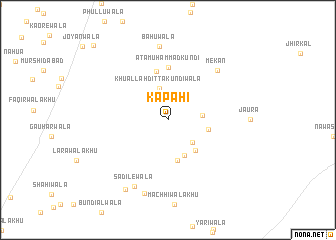
Kapahi (Punjab, Pakistan)Kapahi is a town in the Punjab region of Pakistan. An overview map of the region around Kapahi is displayed below.
regional and 3d topo map of Kapahi, Pakistan ::
Kapahi airports ::
The nearest airport is LYP - Faisalabad Intl, located 129.6 km east of Kapahi.
Other airports nearby include MUX - Multan Intl (171.8 km south), ISB - Islamabad Chaklala (246.7 km north east), Nearby towns ::
Malik Fateh Muhammadwāla Nalka (3.4km south east) //
Khu Allāh Ditta Kundīwāla (3.6km north) //
Dittawāla Nalka (3.3km east) //
Phattuwāla Nalka (4.3km south) //
Berwāla (4.3km south east) //
Lālugamewāla Nalka (4.6km south) //
Hākimwāla Nalka (4.0km east) //
Pushiāwāla Bhān (5.5km north) //
Ata Muhammad Kundi (5.9km north) //
Mekān (7.3km north east) //
Bāhūwāla (8.2km north) //
Sadilewāla (8.1km south west) //
Koruwāla (8.5km south) //
Bambwāla (8.7km south west) //
Gul Husain Joyāwāla (10.9km north west) //
[all distances 'as the bird flies' and approximate] 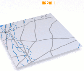 Places with similar names to Kapahi, Pakistan ::
Disclaimer :: Information on this page comes without warranty of any kind |
||
|
Where is Kapahi? Elevation and coordinates ::
Latitude (lat): 31°44'0"N Longitude (lon): 71°42'0"E
Elevation (approx.): 175m (map arrows pan, magnifying glasses zoom) |
||
|
Visiting Kapahi? Hotel/Accommodation ::
Book a hotel in Kapahi Travel Guide ::
Buy a travel guide for Pakistan rental cars ::
car rental offers GPS waypoint ::
download a GPX waypoint (PoI) of Kapahi for your GPS receiver
|
||