|
search place name
|
||
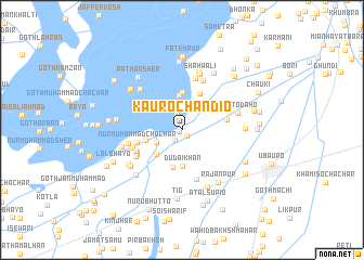
Kauro Chāndio (Sind, Pakistan)Kauro Chāndio is a town in the Sind region of Pakistan. An overview map of the region around Kauro Chāndio is displayed below.
regional and 3d topo map of Kauro Chāndio, Pakistan ::
Kauro Chāndio airports ::
The nearest airport is RYK - Rahim Yar Khan Sheikh Zayed, located 65.1 km east of Kauro Chāndio.
Other airports nearby include SUL - Sui (67.8 km north west), SKZ - Sukkur (99.6 km south west), MJD - Moenjodaro (176.7 km south west), JSA - Jaisalmer (188.3 km south east), Nearby towns ::
Pīrzādan (0.3km south west) //
Basti Muhammad Azīm (0.7km south east) //
Ghāzi Malik (1.3km south west) //
Bāqir (1.7km north) //
Dehkosh (2.2km north) //
Saman Khān Silra (2.4km north) //
Jullan Shaikh (2.6km south west) //
Mag Baloch (3.0km north east) //
Jīwan Budha Māchhi (3.6km north) //
Mochi (3.4km south west) //
Dudāi Khān (3.7km south) //
Arbi Chāchar (3.4km west) //
Wasti Jīwan Shāh (3.9km north) //
Rangpur (3.9km south) //
Jān Muhammad Kori (4.1km north east) //
Fīroz Baloch (4.2km east) //
Nūr Muhammad Chāchar (4.3km west) //
Ghaus Bakhsh (4.7km south west) //
Dodo Chāchar (4.8km south west) //
Sāīndād Chāchar (4.7km south west) //
Ali Akbar Sheni Malik (5.3km south) //
Ālam Chāchar (4.9km west) //
Ramzān Bhutto (5.4km north) //
Saīn Silro (5.4km north) //
Motar Chāchar (5.1km south west) //
Sona Chāchar (5.1km west) //
Chato Daho (5.3km east) //
Allāh Wāsāyo (5.6km north west) //
Shāhwāli (5.9km north) //
[all distances 'as the bird flies' and approximate] 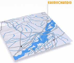 Places with similar names to Kauro Chāndio, Pakistan ::
// Kirchende (DE)
// Guruchāndi (BD)
// Krishnadia (BD)
// Krishnādia (BD)
// Krishnādia (BD)
// Karchond (IN)
// Ker Chaindu (GM)
// Ker Chandeh (GM)
Disclaimer :: Information on this page comes without warranty of any kind |
||
|
Where is Kauro Chāndio? Elevation and coordinates ::
Latitude (lat): 28°11'55"N Longitude (lon): 69°39'0"E
Elevation (approx.): 73m (map arrows pan, magnifying glasses zoom) |
||
|
Visiting Kauro Chāndio? Hotel/Accommodation ::
Book a hotel in Kauro Chāndio Travel Guide ::
Buy a travel guide for Pakistan rental cars ::
car rental offers GPS waypoint ::
download a GPX waypoint (PoI) of Kauro Chāndio for your GPS receiver
|
||