|
search place name
|
||
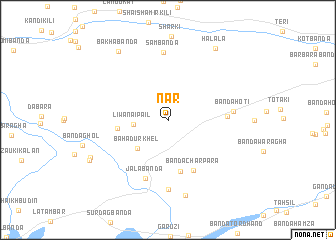
Nār (North-West Frontier, Pakistan)Nār is a town in the North-West Frontier region of Pakistan. An overview map of the region around Nār is displayed below.
regional and 3d topo map of Nār, Pakistan ::
Nār airports ::
The nearest airport is PEW - Peshawar Intl, located 99.8 km north east of Nār.
Other airports nearby include JAA - Jalalabad (139.3 km north), SDT - Saidu Sharif (218.1 km north east), KBL - Kabul Intl (222.4 km north west), PZH - Zhob (250.5 km south west), Nearby towns ::
Liwānai Pail (3.3km west) //
Bahādur Khel (4.3km south west) //
Drish Khel (4.8km west) //
Bānda Charpara (5.8km south) //
Bānda Charpara (6.2km south east) //
Khurram Muhammadzai (5.6km east) //
Jala Bānda (6.9km south) //
Bānda Hoti (6.2km east) //
Sam Bānda (7.5km north) //
Bānda Assār (7.7km south) //
Bānda Assar (8.6km south) //
Bakha Bānda (8.9km north west) //
Halāla (9.2km north east) //
Mīr Hasan Kili (8.4km south west) //
NiāzKili (8.6km south west) //
[all distances 'as the bird flies' and approximate] 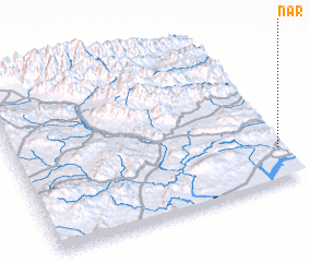 Places with similar names to Nār, Pakistan ::
Disclaimer :: Information on this page comes without warranty of any kind |
||
|
Where is Nār? Elevation and coordinates ::
Latitude (lat): 33°12'40"N Longitude (lon): 70°59'7"E
Elevation (approx.): 631m (map arrows pan, magnifying glasses zoom) |
||
|
Visiting Nār? Hotel/Accommodation ::
Book a hotel in Nār Travel Guide ::
Buy a travel guide for Pakistan rental cars ::
car rental offers GPS waypoint ::
download a GPX waypoint (PoI) of Nār for your GPS receiver
|
||