|
search place name
|
||
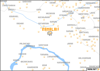
Ramalai (Federally Administered Tribal Areas, Pakistan)Ramalai is a town in the Federally Administered Tribal Areas region of Pakistan. An overview map of the region around Ramalai is displayed below.
regional and 3d topo map of Ramalai, Pakistan ::
Ramalai airports ::
The nearest airport is PEW - Peshawar Intl, located 48.8 km south east of Ramalai.
Other airports nearby include JAA - Jalalabad (68.9 km west), SDT - Saidu Sharif (112.6 km north east), ISB - Islamabad Chaklala (190.6 km south east), Nearby towns ::
Ramalai (0.4km east) //
Ahad Korūna (1.1km north) //
Ata Jawar (2.2km north west) //
Zor Gudai Tangi (2.7km north east) //
Nawe Gudai Tangi (3.2km north) //
Gat Warsak (4.1km north west) //
Shāh Katol (4.1km north west) //
Surdāg (4.4km north) //
Khān Beg Kor (3.8km west) //
Zahāwar Chīna (4.3km north east) //
Sira Tigga (4.9km south west) //
Toratigga (4.7km east) //
Wucha Jāwar (6.3km north) //
Ato Khel (7.0km north) //
Mazarina (7.4km north) //
Surdāg (6.2km east) //
Khuram Chīna (6.5km east) //
Tor Dand (8.3km south) //
Ato Khel (7.9km north east) //
Jārān (7.4km south east) //
Darre Kili (7.4km north east) //
Shīnpokh (7.8km south west) //
Lande Narai (8.9km south) //
Mozi Kor Kili (9.0km north east) //
Darwāzgai (9.8km north east) //
Kasai (10.0km north east) //
[all distances 'as the bird flies' and approximate]  Places with similar names to Ramalai, Pakistan ::
Disclaimer :: Information on this page comes without warranty of any kind |
||
|
Where is Ramalai? Elevation and coordinates ::
Latitude (lat): 34°22'25"N Longitude (lon): 71°14'50"E
Elevation (approx.): 843m (map arrows pan, magnifying glasses zoom) |
||
|
Visiting Ramalai? Hotel/Accommodation ::
Book a hotel in Ramalai Travel Guide ::
Buy a travel guide for Pakistan rental cars ::
car rental offers GPS waypoint ::
download a GPX waypoint (PoI) of Ramalai for your GPS receiver
|
||