|
search place name
|
||
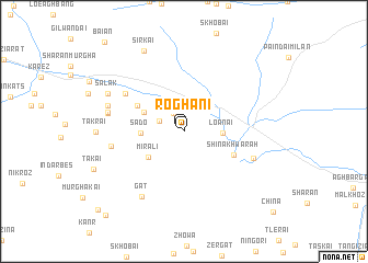
Roghāni (Balochistān, Pakistan)Roghāni is a town in the Balochistān region of Pakistan. An overview map of the region around Roghāni is displayed below.
regional and 3d topo map of Roghāni, Pakistan ::
Roghāni airports ::
The nearest airport is UET - Quetta, located 124.2 km south west of Roghāni.
Other airports nearby include PZH - Zhob (154.0 km east), Nearby towns ::
Roghāni (0.3km north) //
Desal (2.0km north west) //
Koibār (2.4km north west) //
Loānai (3.4km east) //
Sado (3.8km west) //
Mīr Ali (4.1km south west) //
Sultān Muhammad (4.1km north west) //
Siddīq (4.8km north west) //
Shīna Khwārah (4.9km south east) //
Bābu Chīna (6.4km north west) //
Koli Chīna (6.6km south east) //
Ghonze (6.5km west) //
Gat (7.6km south west) //
Saifuddīn (6.9km west) //
Mughal Chīna (7.0km west) //
Khushdil (7.2km west) //
Salak (7.7km north west) //
Sirkai (8.9km north west) //
Dādar (10.9km south west) //
Tor Tangi (11.0km south west) //
[all distances 'as the bird flies' and approximate]  Places with similar names to Roghāni, Pakistan ::
Disclaimer :: Information on this page comes without warranty of any kind |
||
|
Where is Roghāni? Elevation and coordinates ::
Latitude (lat): 30°59'55"N Longitude (lon): 67°54'13"E
Elevation (approx.): 2137m (map arrows pan, magnifying glasses zoom) |
||
|
Visiting Roghāni? Hotel/Accommodation ::
Book a hotel in Roghāni Travel Guide ::
Buy a travel guide for Pakistan rental cars ::
car rental offers GPS waypoint ::
download a GPX waypoint (PoI) of Roghāni for your GPS receiver
|
||