|
search place name
|
||
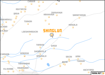
Shinglūn (Balochistān, Pakistan)Shinglūn is a town in the Balochistān region of Pakistan. An overview map of the region around Shinglūn is displayed below.
regional and 3d topo map of Shinglūn, Pakistan ::
Shinglūn airports ::
The nearest airport is UET - Quetta, located 19.3 km south west of Shinglūn.
Other airports nearby include KDH - Kandahar (176.5 km north west), Nearby towns ::
Ghundak (2.5km east) //
Dirga (3.8km south) //
Sarwastale Khum (5.0km north) //
Tarakai (5.2km south west) //
Kāhi Khum (6.5km north) //
Shebak Kile (7.0km south west) //
Makhi Khum (7.4km north) //
Zaindi Khum (8.0km north) //
Mangala (7.3km north east) //
Loe Shīn Maghzai (7.1km west) //
Sra Khula (8.3km south west) //
Saizai (9.2km south east) //
Tsāhgai (9.0km north west) //
Sāhibzāda (9.8km south east) //
[all distances 'as the bird flies' and approximate] 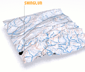 Places with similar names to Shinglūn, Pakistan ::
// Shangalon (MM)
// Chancolín (GT)
// Chongoleani (TZ)
// Changlāni (PK)
// Changulāni (PK)
// Shinglūn (PK)
// Chinguiliani (PE)
// Chunquilani (PE)
// Changalane (MZ)
// Changolene (MZ)
Disclaimer :: Information on this page comes without warranty of any kind |
||
|
Where is Shinglūn? Elevation and coordinates ::
Latitude (lat): 30°20'33"N Longitude (lon): 67°6'33"E
Elevation (approx.): 1985m (map arrows pan, magnifying glasses zoom) |
||
|
Visiting Shinglūn? Hotel/Accommodation ::
Book a hotel in Shinglūn Travel Guide ::
Buy a travel guide for Pakistan rental cars ::
car rental offers GPS waypoint ::
download a GPX waypoint (PoI) of Shinglūn for your GPS receiver
|
||