|
search place name
|
||
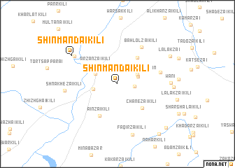
Shīn Māndai Kili (Balochistān, Pakistan)Shīn Māndai Kili is a town in the Balochistān region of Pakistan. An overview map of the region around Shīn Māndai Kili is displayed below.
regional and 3d topo map of Shīn Māndai Kili, Pakistan ::
Shīn Māndai Kili airports ::
The nearest airport is PZH - Zhob, located 25.7 km north east of Shīn Māndai Kili.
Nearby towns ::
Daruzai Kili (2.4km east) //
Asanzai Shaikhān (3.1km north east) //
Warsak Kili (3.1km north east) //
Bādīnzai (3.5km north west) //
Bādīnzai Kili (3.4km west) //
Arzanzai Kili (4.1km north west) //
Horkai Kili (4.9km north east) //
Chanezai Kili (5.1km south east) //
Ainzai Kili (5.6km south west) //
Bahlolzai Kili (6.7km north east) //
Mārapzai (6.1km east) //
Huramzai Kili (7.3km north west) //
Faqīrzai Kili (8.3km south) //
Shna Khezai Kili (7.3km west) //
Wāni (7.3km east) //
Shīnmāndai Kili (7.7km north west) //
Lālakzai (8.5km north east) //
Ghorshai Kili (9.8km south east) //
Dābak Kili (9.6km south east) //
[all distances 'as the bird flies' and approximate]  Places with similar names to Shīn Māndai Kili, Pakistan ::
// Shīnmāndai Kili (PK)
Disclaimer :: Information on this page comes without warranty of any kind |
||
|
Where is Shīn Māndai Kili? Elevation and coordinates ::
Latitude (lat): 31°9'59"N Longitude (lon): 69°18'47"E
Elevation (approx.): 1473m (map arrows pan, magnifying glasses zoom) |
||
|
Visiting Shīn Māndai Kili? Hotel/Accommodation ::
Book a hotel in Shīn Māndai Kili Travel Guide ::
Buy a travel guide for Pakistan rental cars ::
car rental offers GPS waypoint ::
download a GPX waypoint (PoI) of Shīn Māndai Kili for your GPS receiver
|
||