|
search place name
|
||
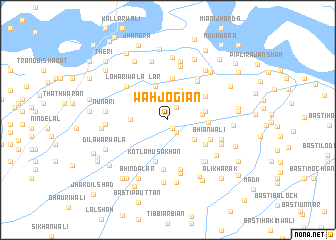
Wāh Jogiān (Punjab, Pakistan)Wāh Jogiān is a town in the Punjab region of Pakistan. An overview map of the region around Wāh Jogiān is displayed below.
regional and 3d topo map of Wāh Jogiān, Pakistan ::
Wāh Jogiān airports ::
The nearest airport is MUX - Multan Intl, located 100.9 km north of Wāh Jogiān.
Other airports nearby include RYK - Rahim Yar Khan Sheikh Zayed (138.1 km south west), Nearby towns ::
Wāranwāla (1.0km south east) //
Kotla Sultān Ahmad (1.6km south east) //
Basti Zar Kharīd (1.6km north east) //
Dhorewāla (3.5km north) //
Langāhwāli (3.4km south east) //
Jhamtiāhwāli Basti (3.4km east) //
Lār (3.9km north) //
Hāmidpur Kalān (3.6km west) //
Nandpura (3.8km east) //
Jhamat (3.9km east) //
Hateji (4.7km north) //
Kotla Mūsa Khān (4.8km south) //
Channar (4.5km north east) //
Paloli (4.6km south east) //
Bhiānwāli (4.7km south east) //
Chak Govind (5.2km north east) //
Pathānwāla (5.6km south) //
Basti Wains (5.4km north east) //
Makhdūmwāla (5.7km south) //
Lohārīwāla (5.5km north west) //
Balochwāli (5.8km south east) //
Basti Malkāni (6.1km south) //
Arāīnwāla (6.1km north) //
Sangarwāhān (5.9km south east) //
Garhi Kandi (5.7km east) //
Dhāwāli (5.9km south east) //
Hāji ki Haveli (6.6km north) //
Basti Khokhrān (6.2km south east) //
Mādhowāla (6.7km north) //
[all distances 'as the bird flies' and approximate] 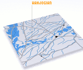 Places with similar names to Wāh Jogiān, Pakistan :: Disclaimer :: Information on this page comes without warranty of any kind |
||
|
Where is Wāh Jogiān? Elevation and coordinates ::
Latitude (lat): 29°18'30"N Longitude (lon): 71°13'45"E
Elevation (approx.): 106m (map arrows pan, magnifying glasses zoom) |
||
|
Visiting Wāh Jogiān? Hotel/Accommodation ::
Book a hotel in Wāh Jogiān Travel Guide ::
Buy a travel guide for Pakistan rental cars ::
car rental offers GPS waypoint ::
download a GPX waypoint (PoI) of Wāh Jogiān for your GPS receiver
|
||