|
search place name
|
||
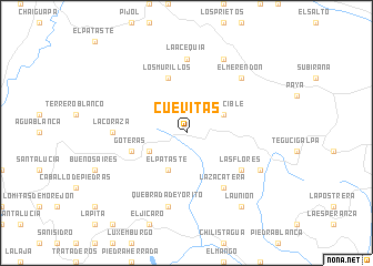
Cuevitas (Yoro, Honduras)Cuevitas is a town in the Yoro region of Honduras. An overview map of the region around Cuevitas is displayed below.
regional and 3d topo map of Cuevitas, Honduras ::
Cuevitas airports ::
The nearest airport is SAP - San Pedro Sula La Mesa Intl, located 50.9 km north west of Cuevitas.
Other airports nearby include TEA - Tela (69.9 km north), LCE - La Ceiba Goloson Intl (100.8 km north east), TGU - Tegucigalpa Toncontin Intl (126.3 km south), RTB - Roatan Juan Manuel Galvez Intl (170.8 km north east), Nearby towns ::
El Pataste (4.1km south west) //
El Sargento (4.0km south west) //
El Apacible (4.0km north east) //
Los Murillos (5.8km north) //
Goteras (5.7km west) //
Las Flores (6.5km south east) //
La Zacatera (6.6km south east) //
La Coraza (7.2km west) //
Camalote (7.4km north) //
La Acequia (7.4km north) //
Quebrada de Yorito (7.6km south) //
El Merendón (7.7km north east) //
El Paraíso de las Flores (8.1km south east) //
El Pedregal (8.2km north east) //
La Unión (9.2km south east) //
[all distances 'as the bird flies' and approximate] 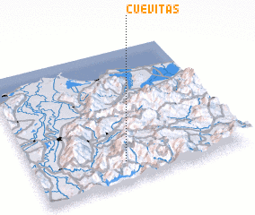 Places with similar names to Cuevitas, Honduras ::
Disclaimer :: Information on this page comes without warranty of any kind |
||
|
Where is Cuevitas? Elevation and coordinates ::
Latitude (lat): 15°9'0"N Longitude (lon): 87°34'0"W
Elevation (approx.): 1108m (map arrows pan, magnifying glasses zoom) |
||
|
Visiting Cuevitas? Hotel/Accommodation ::
Book a hotel in Cuevitas Travel Guide ::
Buy a travel guide for Honduras rental cars ::
car rental offers GPS waypoint ::
download a GPX waypoint (PoI) of Cuevitas for your GPS receiver
|
||