|
search place name
|
||
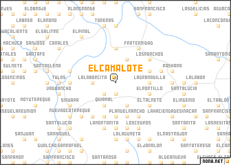
El Camalote (Ocotepeque, Honduras)El Camalote is a town in the Ocotepeque region of Honduras. An overview map of the region around El Camalote is displayed below.
regional and 3d topo map of El Camalote, Honduras ::
El Camalote airports ::
The nearest airport is SAL - San Salvador El Salvador Intl, located 115.5 km south of El Camalote.
Other airports nearby include GUA - Guatemala City La Aurora (152.5 km west), SAP - San Pedro Sula La Mesa Intl (167.3 km north east), CBV - Coban (176.5 km north west), TGU - Tegucigalpa Toncontin Intl (210.2 km east), Nearby towns ::
El Moral (1.9km south) //
Tepezcuintle (1.9km south) //
El Carrizal (2.6km south west) //
La Laborcita (3.6km west) //
Quiamal (4.1km south west) //
San Rafael de las Mataras (4.1km south west) //
El Malcote (4.1km south east) //
Los Ejidos (4.1km north east) //
La Granadilla (5.4km east) //
Dolores (5.6km north) //
El Naranjo (5.6km south) //
El Ocotillo (5.6km south) //
Casa de Teja (5.6km south) //
El Portillo (5.7km east) //
Cacalguapa (5.8km south) //
El Matasano (5.7km east) //
Plan del Rancho (5.8km south) //
El Talnete (6.5km south east) //
Mercedes (6.6km south west) //
Fraternidad (6.6km north east) //
El Chorro (6.6km south east) //
El Guamilar (6.6km south east) //
Los Ranchos (6.5km north east) //
El Sauce (7.4km south) //
El Peñasco (7.2km west) //
La Montañita (7.6km south) //
El Volcancito (7.6km south) //
Sacamil (7.4km west) //
Las Vegas (7.4km east) //
[all distances 'as the bird flies' and approximate] 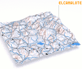 Places with similar names to El Camalote, Honduras ::
// El Camalote (CU)
// El Camalote (SV)
// El Camalote (SV)
// El Camalote (GT)
// El Camalote (MX)
// El Camalote (MX)
// El Camalote (MX)
// El Camalote (HN)
// El Camalote (HN)
// El Camalote (HN)
Disclaimer :: Information on this page comes without warranty of any kind |
||
|
Where is El Camalote? Elevation and coordinates ::
Latitude (lat): 14°29'0"N Longitude (lon): 89°7'0"W
Elevation (approx.): 1463m (map arrows pan, magnifying glasses zoom) |
||
|
Visiting El Camalote? Hotel/Accommodation ::
Book a hotel in El Camalote Travel Guide ::
Buy a travel guide for Honduras rental cars ::
car rental offers GPS waypoint ::
download a GPX waypoint (PoI) of El Camalote for your GPS receiver
|
||