|
search place name
|
||
El Nancital (Choluteca, Honduras)El Nancital is a town in the Choluteca region of Honduras. An overview map of the region around El Nancital is displayed below.
regional and 3d topo map of El Nancital, Honduras ::

El Nancital airports ::
The nearest airport is TGU - Tegucigalpa Toncontin Intl, located 89.2 km north of El Nancital.
Other airports nearby include MGA - Managua Intl (155.3 km south east), Nearby towns ::
La Montaña (0.0km north) //
San Juan (0.0km north) //
San Judas (1.4km south west) //
El Potrero (1.9km south) //
La Cabrera (1.9km north) //
El Baldoquín (1.9km north) //
El Porvenir (1.9km north) //
El Moropo (1.8km west) //
El Banco (1.8km west) //
San Judas (1.8km east) //
El Jocote (1.8km west) //
Hacienda El Portila (2.3km north west) //
La Jagüita (2.6km south west) //
El Quebrachal (2.6km north west) //
El Caracol (2.7km south west) //
El Trapiche (2.8km north) //
Ojo de Agua (3.2km south) //
Guajiniquil (3.1km south west) //
Apinto (3.5km south west) //
Aguacatal (3.6km west) //
Las Casitas (3.6km west) //
Los Llanitos (3.7km south) //
La Anona (3.7km north) //
Huatales (3.7km south west) //
El Cacao (3.7km west) //
El Peñón (3.9km south) //
Corpus (3.8km west) //
Las Vegas (4.1km south west) //
El Portillo (4.1km south west) //
[all distances 'as the bird flies' and approximate] 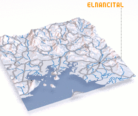 Places with similar names to El Nancital, Honduras ::
// El Nancital (NI)
Disclaimer :: Information on this page comes without warranty of any kind |
||
|
Where is El Nancital? Elevation and coordinates ::
Latitude (lat): 13°17'0"N Longitude (lon): 87°0'0"W
Elevation (approx.): 834m (map arrows pan, magnifying glasses zoom) |
||
|
Visiting El Nancital? Hotel/Accommodation ::
Book a hotel in El Nancital Travel Guide ::
Buy a travel guide for Honduras rental cars ::
car rental offers GPS waypoint ::
download a GPX waypoint (PoI) of El Nancital for your GPS receiver
|
||