|
search place name
|
||
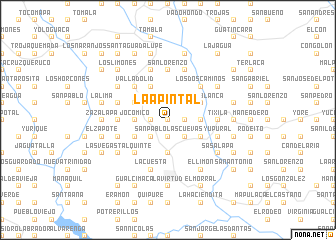
La Apintal (Lempira, Honduras)La Apintal is a town in the Lempira region of Honduras. An overview map of the region around La Apintal is displayed below.
regional and 3d topo map of La Apintal, Honduras ::
La Apintal airports ::
The nearest airport is SAL - San Salvador El Salvador Intl, located 84.1 km south west of La Apintal.
Other airports nearby include TGU - Tegucigalpa Toncontin Intl (160.3 km east), SAP - San Pedro Sula La Mesa Intl (169.8 km north east), GUA - Guatemala City La Aurora (203.8 km west), TEA - Tela (225.9 km north east), Nearby towns ::
Plan de las Peñas (0.0km north) //
Cucurucho (1.9km south) //
Catulaca (1.8km east) //
La Ciénega (1.8km west) //
El Astillero (2.6km north east) //
Agua Zarca (2.6km north east) //
El Limón (2.6km north east) //
San Juan (2.6km south west) //
Las Cuevas (2.6km south east) //
Roblar Tupido (2.6km south east) //
San Pablo (2.6km south west) //
Piedra Grande (2.6km south east) //
Las Veguitas (2.6km south east) //
Piedra del Tigre (3.6km west) //
Jocomico (3.6km west) //
El Zope (3.6km east) //
Portillo de la Quesera (3.6km east) //
Guajiniquil (3.7km south) //
El Valle (4.0km north west) //
Tierra Blanca (4.0km north east) //
El Tablón (4.0km north east) //
La Trinidad (4.0km north east) //
Gilona (4.0km south west) //
La Vega (4.0km south west) //
La Cañada (4.0km south west) //
Santa Bárbara (4.1km north west) //
Laja Blanca (4.1km north west) //
San Francisco (4.0km south east) //
Apantes (4.0km south east) //
[all distances 'as the bird flies' and approximate]  Places with similar names to La Apintal, Honduras ::
// La Puntilla (CU)
// La Puntilla (CL)
// La Puntilla (EC)
// La Puntilla (EC)
// La Pantalla (MX)
// La Puntilla (MX)
// La Puntilla (HN)
// La Puntilla (PE)
// La Puntilla (PE)
// La Puntilla (PE)
Disclaimer :: Information on this page comes without warranty of any kind |
||
|
Where is La Apintal? Elevation and coordinates ::
Latitude (lat): 14°7'0"N Longitude (lon): 88°42'0"W
Elevation (approx.): 394m (map arrows pan, magnifying glasses zoom) |
||
|
Visiting La Apintal? Hotel/Accommodation ::
Book a hotel in La Apintal Travel Guide ::
Buy a travel guide for Honduras rental cars ::
car rental offers GPS waypoint ::
download a GPX waypoint (PoI) of La Apintal for your GPS receiver
|
||