|
search place name
|
||
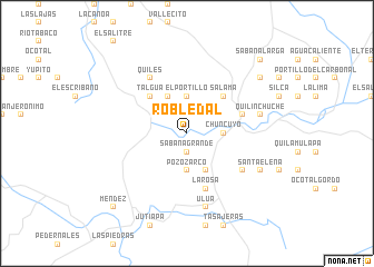
Robledal (Olancho, Honduras)Robledal is a town in the Olancho region of Honduras. An overview map of the region around Robledal is displayed below.
regional and 3d topo map of Robledal, Honduras ::
Robledal airports ::
The nearest airport is TGU - Tegucigalpa Toncontin Intl, located 104.3 km south west of Robledal.
Other airports nearby include LCE - La Ceiba Goloson Intl (107.3 km north), TEA - Tela (142.0 km north west), SAP - San Pedro Sula La Mesa Intl (157.9 km north west), RTB - Roatan Juan Manuel Galvez Intl (168.1 km north), Nearby towns ::
Sabana Grande (1.9km south) //
La Jagua (1.9km north) //
La Pita (2.6km north west) //
El Portillo (3.7km north) //
Cofradía (3.7km north) //
Pozo Zarco (3.7km south) //
Chuncuyo (3.6km east) //
La Cuesta (4.1km north west) //
La Cruz (4.1km south east) //
Talgua (5.2km north west) //
Salamá (5.2km north east) //
El Zuntul (5.7km east) //
La Rosa (5.8km south) //
Guamiles (6.5km south east) //
Quiles (6.6km north west) //
Quilinchuche (7.4km east) //
El Cerro (7.4km east) //
Ulúa (7.6km south) //
Santa Elena (8.1km south east) //
Chucuyo (9.1km north east) //
Méndez (10.3km south west) //
Sabana Larga (10.3km north east) //
[all distances 'as the bird flies' and approximate]  Places with similar names to Robledal, Honduras ::
// Robladillo (ES)
// Robledillo (ES)
// Robledillo (ES)
// Robledal (HN)
// Robledal (HN)
// Robledal (VE)
// Robledal (VE)
Disclaimer :: Information on this page comes without warranty of any kind |
||
|
Where is Robledal? Elevation and coordinates ::
Latitude (lat): 14°48'0"N Longitude (lon): 86°37'0"W
Elevation (approx.): 764m (map arrows pan, magnifying glasses zoom) |
||
|
Visiting Robledal? Hotel/Accommodation ::
Book a hotel in Robledal Travel Guide ::
Buy a travel guide for Honduras rental cars ::
car rental offers GPS waypoint ::
download a GPX waypoint (PoI) of Robledal for your GPS receiver
|
||