|
search place name
|
||
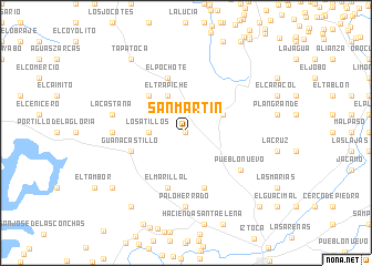
San Martín (Choluteca, Honduras)San Martín is a town in the Choluteca region of Honduras. An overview map of the region around San Martín is displayed below.
regional and 3d topo map of San Martín, Honduras ::
San Martín airports ::
The nearest airport is TGU - Tegucigalpa Toncontin Intl, located 71.5 km north of San Martín.
Other airports nearby include MGA - Managua Intl (184.7 km south east), SAL - San Salvador El Salvador Intl (193.8 km west), Nearby towns ::
La Picota (0.0km north) //
Los Atillos (3.6km west) //
El Trapiche (4.1km north west) //
Agua Caliente de Linaca (4.1km north east) //
El Alcayán (5.2km north west) //
El Pochote (5.8km north) //
El Marillal (5.8km south) //
Guanacastillo (5.7km west) //
Copal Abajo (5.8km south) //
Pueblo Nuevo (6.6km south east) //
Pavana (7.2km west) //
Palo Herrado (7.4km south) //
La Castaña (7.4km west) //
Tapatoca (9.2km north west) //
El Bergantín (9.1km south west) //
El Murciélago (9.2km south west) //
Hato Nuevo (10.3km south east) //
[all distances 'as the bird flies' and approximate]  Places with similar names to San Martín, Honduras ::
// San Martin (US)
// San Martín (PA)
// San Martín (PA)
// San Martino (IT)
// San Martino (IT)
// San Martino (IT)
// San Martino (IT)
// San Martino (IT)
// San Martino (IT)
// San Martino (IT)
Disclaimer :: Information on this page comes without warranty of any kind |
||
|
Where is San Martín? Elevation and coordinates ::
Latitude (lat): 13°25'0"N Longitude (lon): 87°16'0"W
Elevation (approx.): 118m (map arrows pan, magnifying glasses zoom) |
||
|
Visiting San Martín? Hotel/Accommodation ::
Book a hotel in San Martín Travel Guide ::
Buy a travel guide for Honduras rental cars ::
car rental offers GPS waypoint ::
download a GPX waypoint (PoI) of San Martín for your GPS receiver
|
||