|
search place name
|
||
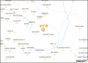
Kitim (Jordan)Kitim is a town in Jordan. An overview map of the region around Kitim is displayed below.
regional and 3d topo map of Kitim, Jordan ::
Kitim airports ::
The nearest airport is OMF - Mafraq King Hussein, located 35.3 km east of Kitim.
Other airports nearby include ADJ - Amman Marka Intl (52.5 km south), RPN - Rosh Pina Mahanaim I Ben Yaakov (67.4 km north west), AMM - Amman Queen Alia Intl (80.0 km south), HFA - Haifa (90.0 km north west), Nearby towns ::
An Nu‘ayyimah (2.6km south east) //
Shaţanā (3.2km west) //
Al Ḩişn (5.6km north) //
Ḩabakā (5.3km north west) //
Aş Şarīḩ (6.7km north) //
Balīlā (6.9km south east) //
Şamad (6.7km west) //
Aydūn (8.4km north west) //
Kafr Khall (9.0km south) //
Şakhrah (9.2km south west) //
Juḩfīyah (9.3km north west) //
Al Mushayrifah (10.4km south east) //
Nāţifah (11.1km north west) //
[all distances 'as the bird flies' and approximate]  Places with similar names to Kitim, Jordan ::
Disclaimer :: Information on this page comes without warranty of any kind |
||
|
Where is Kitim? Elevation and coordinates ::
Latitude (lat): 32°26'22"N Longitude (lon): 35°53'49"E
Elevation (approx.): 778m (map arrows pan, magnifying glasses zoom) |
||
|
Visiting Kitim? Hotel/Accommodation ::
Book a hotel in Kitim Travel Guide ::
Buy a travel guide for Jordan rental cars ::
car rental offers GPS waypoint ::
download a GPX waypoint (PoI) of Kitim for your GPS receiver
|
||