|
search place name
|
||
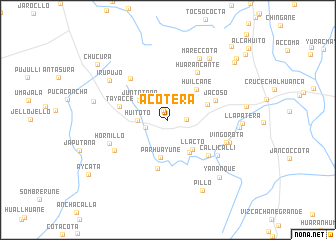
Acotera (Arequipa, Peru)Acotera is a town in the Arequipa region of Peru. An overview map of the region around Acotera is displayed below.
regional and 3d topo map of Acotera, Peru ::
Acotera airports ::
The nearest airport is AQP - Arequipa Rodriguez Ballon, located 58.9 km south of Acotera.
Other airports nearby include JUL - Juliaca (147.9 km east), Nearby towns ::
Condori (1.2km north west) //
Chontaña (2.0km east) //
Yuracc Cancha (2.6km west) //
Huitoto (3.2km west) //
Juntotaña (3.8km north west) //
Parhuayune (4.2km south) //
La Capilla (4.3km south east) //
Llacto (4.3km south east) //
Huilcane (4.6km north east) //
Herohuito (4.6km east) //
Japutaña (5.5km south) //
Tayacce (5.4km west) //
Jacoso (5.5km north east) //
Puyulaca (5.8km south east) //
Ccasahuasi (6.1km north west) //
Huarancante (6.2km north east) //
Callicalli (6.6km south east) //
Platillane (6.7km south west) //
Vingorota (6.7km east) //
Hornillo (6.8km south west) //
Ichuraya (7.1km east) //
Mareccota (7.6km north east) //
Irupujo (7.7km north west) //
Concachaca (7.7km east) //
Antotaña (8.2km north east) //
Llapatera (8.1km east) //
Negra (8.3km west) //
Yananque (8.5km south east) //
Pillo (8.7km south east) //
[all distances 'as the bird flies' and approximate]  Places with similar names to Acotera, Peru ::
Disclaimer :: Information on this page comes without warranty of any kind |
||
|
Where is Acotera? Elevation and coordinates ::
Latitude (lat): 15°48'58"S Longitude (lon): 71°29'23"W
Elevation (approx.): 4406m (map arrows pan, magnifying glasses zoom) |
||
|
Visiting Acotera? Hotel/Accommodation ::
Book a hotel in Acotera Travel Guide ::
Buy a travel guide for Peru rental cars ::
car rental offers GPS waypoint ::
download a GPX waypoint (PoI) of Acotera for your GPS receiver
|
||