|
search place name
|
||
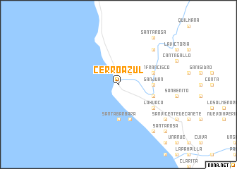
Cerro Azul (Lima, Peru)Cerro Azul is a town in the Lima region of Peru. An overview map of the region around Cerro Azul is displayed below.
regional and 3d topo map of Cerro Azul, Peru ::
Cerro Azul airports ::
The nearest airport is PIO - Pisco Intl, located 83.7 km south of Cerro Azul.
Other airports nearby include LIM - Lima Jorge Chavez Intl (131.2 km north west), Nearby towns ::
Lihuanco (2.6km north east) //
San Juan (5.4km east) //
Santa Bárbara (5.6km south) //
San Pedro (5.8km south) //
San Francisco (5.7km east) //
Casa Blanca (5.7km east) //
La Huaca (6.6km south east) //
La Quebrada (7.8km north east) //
Santa Rosa (9.2km north east) //
Montalván (9.1km south east) //
Arona (9.1km south east) //
San Antonio (9.2km south east) //
San Luis (9.2km south east) //
Santa Rosa (10.3km south east) //
[all distances 'as the bird flies' and approximate] 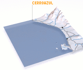 Places with similar names to Cerro Azul, Peru ::
// Şorsulu (AZ)
// Şorsulu (AZ)
// Xoruzlu (AZ)
// Zarıslı (AZ)
// Sarcillo (US)
// Cerrezuela (PA)
// Cerro Azul (PA)
// Cerro Azul (PA)
// Cerasola (IT)
// Cerasolo (IT)
Disclaimer :: Information on this page comes without warranty of any kind |
||
|
Where is Cerro Azul? Elevation and coordinates ::
Latitude (lat): 13°2'0"S Longitude (lon): 76°29'0"W
Elevation (approx.): 20m (map arrows pan, magnifying glasses zoom) |
||
|
Visiting Cerro Azul? Hotel/Accommodation ::
Book a hotel in Cerro Azul Travel Guide ::
Buy a travel guide for Peru rental cars ::
car rental offers GPS waypoint ::
download a GPX waypoint (PoI) of Cerro Azul for your GPS receiver
|
||