|
search place name
|
||
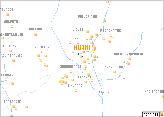
Huami (Arequipa, Peru)Huami is a town in the Arequipa region of Peru. An overview map of the region around Huami is displayed below.
regional and 3d topo map of Huami, Peru ::
Huami airports ::
The nearest airport is AQP - Arequipa Rodriguez Ballon, located 123.2 km south east of Huami.
Other airports nearby include ANS - Andahuaylas (237.1 km north), Nearby towns ::
Chipcoma (0.4km south east) //
Turupatio (0.5km north) //
Pucapuca (0.7km west) //
Conte (1.0km south east) //
Riruy (1.1km north west) //
Yaso (1.2km north east) //
Chaelhue (1.2km east) //
Huascasca (1.7km north) //
Ccallhuajoto (1.8km south east) //
Tagre (2.0km south east) //
Parcay (2.1km north) //
Santa Ana (2.2km north east) //
Chupacea (2.5km south) //
Pillcull (2.5km north west) //
Calihuayoc (2.5km north east) //
Pampachacra (2.6km west) //
Yayan (2.7km south east) //
Arejocha (2.7km north) //
Agua Santa (2.7km east) //
Ensenada (2.8km east) //
Chaquirca (2.9km north) //
Tarayoc (2.8km east) //
Arhuín (3.0km north east) //
Llato (3.2km south) //
Quillilli (3.2km north east) //
Taparza (3.1km east) //
Tada (3.5km north) //
Chupan (3.5km north east) //
Pituro (3.6km north east) //
[all distances 'as the bird flies' and approximate] 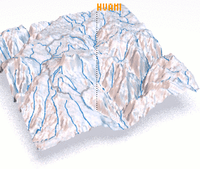 Places with similar names to Huami, Peru ::
Disclaimer :: Information on this page comes without warranty of any kind |
||
|
Where is Huami? Elevation and coordinates ::
Latitude (lat): 15°41'22"S Longitude (lon): 72°30'59"W
Elevation (approx.): 2390m (map arrows pan, magnifying glasses zoom) |
||
|
Visiting Huami? Hotel/Accommodation ::
Book a hotel in Huami Travel Guide ::
Buy a travel guide for Peru rental cars ::
car rental offers GPS waypoint ::
download a GPX waypoint (PoI) of Huami for your GPS receiver
|
||